Seguin elevation
Seguin (Texas, Guadalupe County), United States elevation is 165 meters and Seguin elevation in feet is 541 ft above sea level [src 1]. Seguin is a seat of a second-order administrative division (feature code) with elevation that is 114 meters (374 ft) smaller than average city elevation in United States.
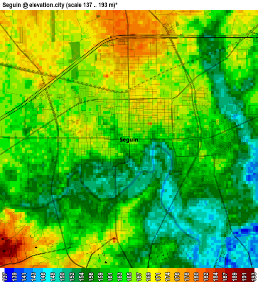
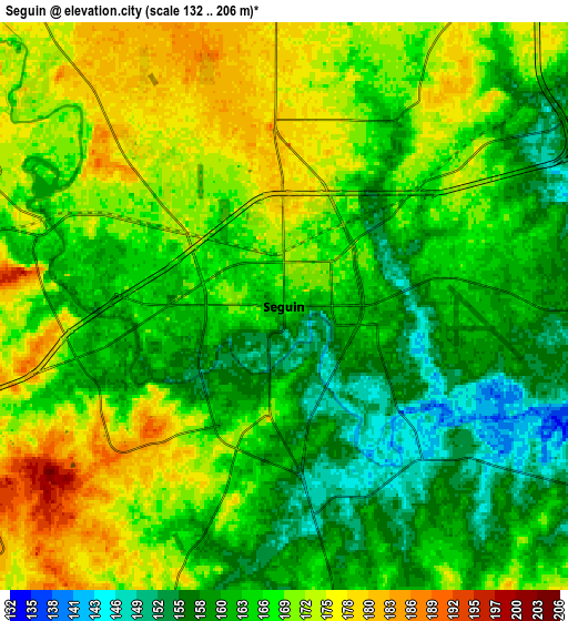
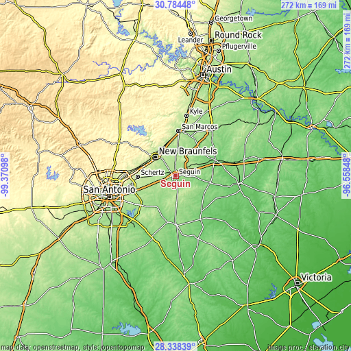
Below is the Elevation map of Seguin, which displays elevation range with different colors. Scale of the first map is from 137 to 193 m (449 to 633 ft) with average elevation of 162.7 meters (=534 ft) [note 1]
These maps also provides idea of topography and contour of this city, they are displayed at different zoom levels. More info about maps, scale and edge coordinates you can find below images.
| \ | Map #1 | Map #2 | Topo.Map |
| Scale [m] | 137..193 m | 132..206 m | × |
| Scale [ft] | 449..633 ft | 433..676 ft | × |
| Average | 162.7 m = 534 ft | 166.3 m = 546 ft | × |
| Width | 8.5 km = 5.3 mi | 17 km = 10.6 mi | 272 km = 169 mi |
| Height | 8.5 km = 5.3 mi | 17 km = 10.6 mi | 272 km = 169 mi |
| ↑Max Latitude | 29.607055° | 29.645255° | 30.78448° |
| Latitude at center | 29.56884° | 29.56884° | 29.56884° |
| ↓Min Latitude | 29.530611° | 29.492367° | 28.33839° |
| ← Min Longitude | -98.008675° | -98.052621° | -99.37098° |
| Longitude center | -97.96473° | -97.96473° | -97.96473° |
| →Max Longitude | -97.920785° | -97.876839° | -96.55848° |
Nearby cities:
Cities around Seguin sort by population:
• New Braunfels elevation 194 m
21.5 km,  314°
314°
• Schertz 220 m
29.6 km,  266°
266°
• Cibolo 217 m
25.4 km, 268°
• Universal City 236 m
31.7 km, 265°
• Redwood 171 m
27.3 km,  10°
10°
• McQueeney 169 m
7.1 km,  291°
291°
• Saint Hedwig 181 m
28.5 km,  232°
232°
• Northcliff 253 m
25.8 km,  283°
283°
• Lake Dunlap 182 m
15.8 km,  318°
318°
• La Vernia 153 m
27.8 km,  211°
211°
• Marion 199 m
17 km, 270°
• Geronimo 181 m
10.5 km,  358°
358°
Multilingual:
 En español:
Seguin elevación 165 m.
 En France:
Seguin élévation 165 m.


Sources and notes:
- [note 1] Map square and city borders are not equal. Map elevation data is calculated only from area inside that square.
- [src 1] Elevation data from geonames database provided with same terms of usage.
- [src 2] The elevation map of Seguin is generated using elevation data from NASA's 3 arcsec (90m) resolution SRTM data.
- [src 3] Base (background) map © OpenStreetMap contributors tiles are generated by Geofabrik and OpenTopoMap.
Copyright & License:
This Seguin Elevation Map is licensed under CC BY-SA. You may reuse any part from this page, if you give a proper credit by linking to this URL:
 More info on terms of use page.