Gonzales elevation
Gonzales (Texas, Gonzales County), United States elevation is 94 meters and Gonzales elevation in feet is 308 ft above sea level [src 1]. Gonzales is a seat of a second-order administrative division (feature code) with elevation that is 185 meters (607 ft) smaller than average city elevation in United States.
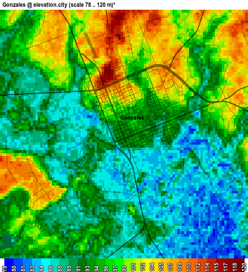
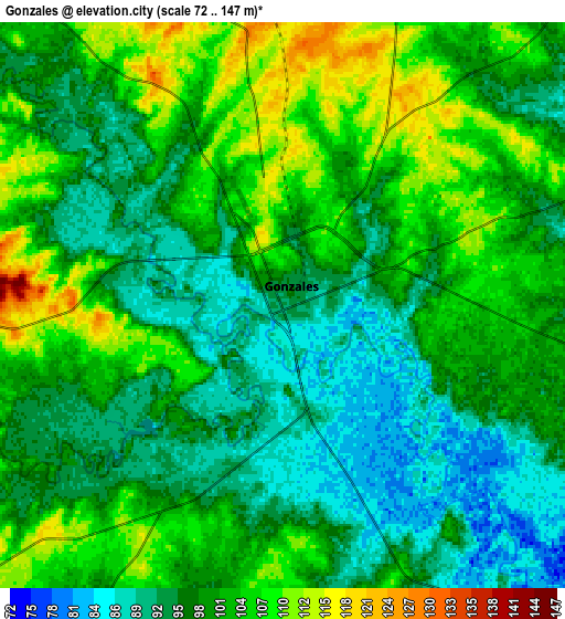
Below is the Elevation map of Gonzales, which displays elevation range with different colors. Scale of the first map is from 78 to 120 m (256 to 394 ft) with average elevation of 93.9 meters (=308 ft) [note 1]
These maps also provides idea of topography and contour of this city, they are displayed at different zoom levels. More info about maps, scale and edge coordinates you can find below images.
| \ | Map #1 | Map #2 | Topo.Map |
| Scale [m] | 78..120 m | 72..147 m | × |
| Scale [ft] | 256..394 ft | 236..482 ft | × |
| Average | 93.9 m = 308 ft | 99.2 m = 325 ft | × |
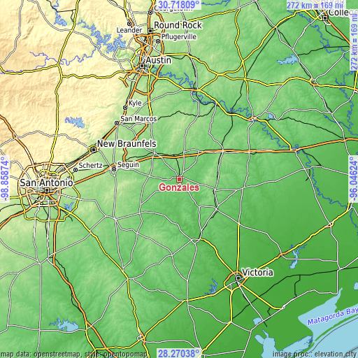
| Width | 8.51 km = 5.3 mi | 17.01 km = 10.6 mi | 272.2 km = 169.1 mi |
| Height | 8.51 km = 5.3 mi | 17.01 km = 10.6 mi | 272.2 km = 169.1 mi |
| ↑Max Latitude | 29.53987° | 29.578096° | 30.71809° |
| Latitude at center | 29.50163° | 29.50163° | 29.50163° |
| ↓Min Latitude | 29.463375° | 29.425106° | 28.27038° |
| ← Min Longitude | -97.496435° | -97.540381° | -98.85874° |
| Longitude center | -97.45249° | -97.45249° | -97.45249° |
| →Max Longitude | -97.408545° | -97.364599° | -96.04624° |
Nearby cities:
Cities around Gonzales sort by population:
• Seguin elevation 165 m
50.1 km,  278°
278°
• Lockhart 160 m
47.5 km,  333°
333°
• Cuero 60 m
48 km,  160°
160°
• Yoakum 101 m
37.6 km,  129°
129°
• Luling 129 m
27.4 km,  316°
316°
• Redwood 171 m
56.1 km,  307°
307°
• Hallettsville 76 m
49.9 km,  97°
97°
• Nixon 124 m
39.9 km,  229°
229°
• Shiner 113 m
28.5 km,  106°
106°
• Flatonia 142 m
39.2 km,  58°
58°
• Martindale 166 m
53.6 km, 315°
• Geronimo 181 m
52.9 km,  289°
289°
Multilingual:
 En español:
Gonzáles elevación 94 m.
 En France:
Gonzales élévation 94 m.


Sources and notes:
- [note 1] Map square and city borders are not equal. Map elevation data is calculated only from area inside that square.
- [src 1] Elevation data from geonames database provided with same terms of usage.
- [src 2] The elevation map of Gonzales is generated using elevation data from NASA's 3 arcsec (90m) resolution SRTM data.
- [src 3] Base (background) map © OpenStreetMap contributors tiles are generated by Geofabrik and OpenTopoMap.
Copyright & License:
This Gonzales Elevation Map is licensed under CC BY-SA. You may reuse any part from this page, if you give a proper credit by linking to this URL:
 More info on terms of use page.