Grandview elevation
Grandview (Texas, Johnson County), United States elevation is 217 meters and Grandview elevation in feet is 712 ft above sea level [src 1]. Grandview is a populated place (feature code) with elevation that is 62 meters (203 ft) smaller than average city elevation in United States.
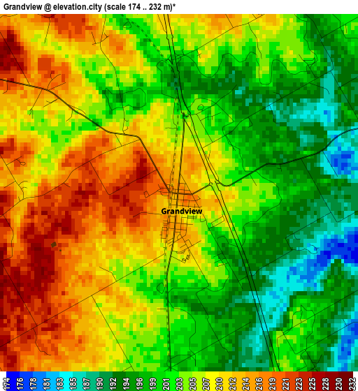
Below is the Elevation map of Grandview, which displays elevation range with different colors. Scale of the first map is from 174 to 232 m (571 to 761 ft) with average elevation of 205 meters (=673 ft) [note 1]
These maps also provides idea of topography and contour of this city, they are displayed at different zoom levels. More info about maps, scale and edge coordinates you can find below images.
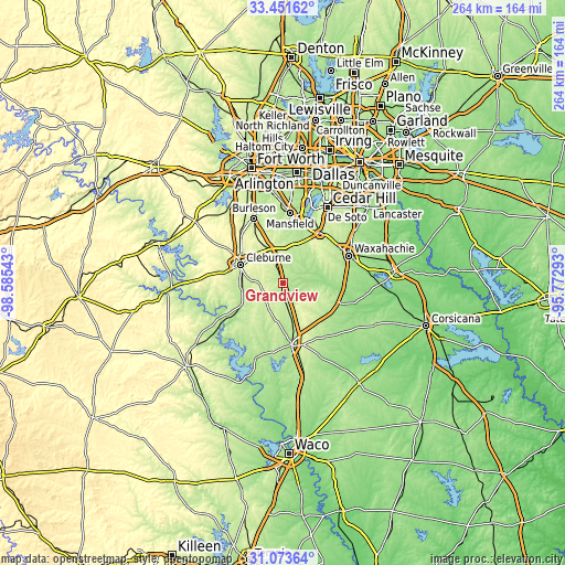
| \ | Map #1 | Topo.Map |
| Scale [m] | 174..232 m | × |
| Scale [ft] | 571..761 ft | × |
| Average | 205 m = 673 ft | × |
| Width | 8.26 km = 5.1 mi | 264.4 km = 164.3 mi |
| Height | 8.26 km = 5.1 mi | 264.4 km = 164.3 mi |
| ↑Max Latitude | 32.30757° | 33.45162° |
| Latitude at center | 32.27042° | 32.27042° |
| ↓Min Latitude | 32.233255° | 31.07364° |
| ← Min Longitude | -97.223125° | -98.58543° |
| Longitude center | -97.17918° | -97.17918° |
| →Max Longitude | -97.135235° | -95.77293° |
Nearby cities:
Cities around Grandview sort by population:
• Mansfield elevation 188 m
32.7 km,  6°
6°
• Burleson 220 m
33 km,  336°
336°
• Cleburne 240 m
21.3 km,  293°
293°
• Midlothian 233 m
29.3 km,  36°
36°
• Hillsboro 197 m
29.2 km,  170°
170°
• Keene 279 m
19.6 km,  315°
315°
• Joshua 289 m
28.9 km, 317°
• Alvarado 237 m
15.4 km,  348°
348°
• Venus 207 m
19.5 km,  21°
21°
• Italy 175 m
29.3 km,  109°
109°
• Itasca 218 m
12.6 km, 167°
• Plum Grove 230 m
19.7 km, 114°
Multilingual:
 En español:
Grandview elevación 217 m.
 En France:
Grandview élévation 217 m.
 Auf Deutsch:
Grandview höhe über dem Meeresspiegel ist 217 m.

Sources and notes:
- [note 1] Map square and city borders are not equal. Map elevation data is calculated only from area inside that square.
- [src 1] Elevation data from geonames database provided with same terms of usage.
- [src 2] The elevation map of Grandview is generated using elevation data from NASA's 3 arcsec (90m) resolution SRTM data.
- [src 3] Base (background) map © OpenStreetMap contributors tiles are generated by Geofabrik and OpenTopoMap.
Copyright & License:
This Grandview Elevation Map is licensed under CC BY-SA. You may reuse any part from this page, if you give a proper credit by linking to this URL:
 More info on terms of use page.