Emory elevation
Emory (Texas, Rains County), United States elevation is 145 meters and Emory elevation in feet is 476 ft above sea level [src 1]. Emory is a seat of a second-order administrative division (feature code) with elevation that is 134 meters (440 ft) smaller than average city elevation in United States.
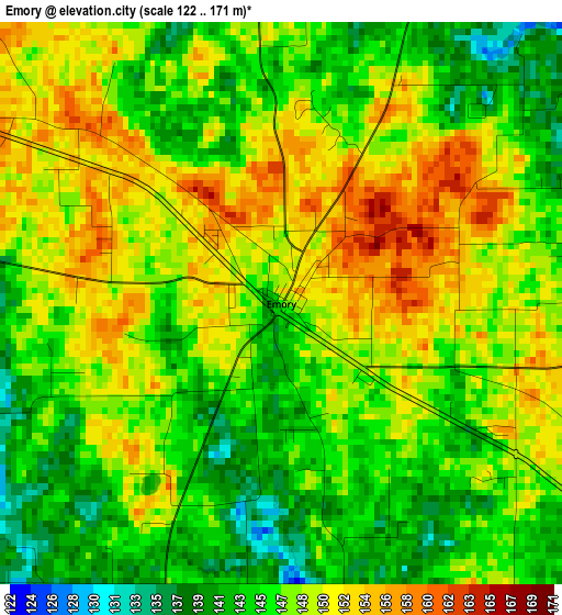
Below is the Elevation map of Emory, which displays elevation range with different colors. Scale of the first map is from 122 to 171 m (400 to 561 ft) with average elevation of 147.3 meters (=483 ft) [note 1]
These maps also provides idea of topography and contour of this city, they are displayed at different zoom levels. More info about maps, scale and edge coordinates you can find below images.
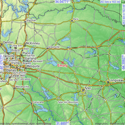
| \ | Map #1 | Topo.Map |
| Scale [m] | 122..171 m | × |
| Scale [ft] | 400..561 ft | × |
| Average | 147.3 m = 483 ft | × |
| Width | 8.21 km = 5.1 mi | 262.6 km = 163.2 mi |
| Height | 8.21 km = 5.1 mi | 262.6 km = 163.2 mi |
| ↑Max Latitude | 32.91147° | 34.04771° |
| Latitude at center | 32.87457° | 32.87457° |
| ↓Min Latitude | 32.837654° | 31.6857° |
| ← Min Longitude | -95.809465° | -97.17177° |
| Longitude center | -95.76552° | -95.76552° |
| →Max Longitude | -95.721575° | -94.35927° |
Nearby cities:
Cities around Emory sort by population:
• Sulphur Springs elevation 158 m
33.1 km,  27°
27°
• Commerce 172 m
43.3 km,  343°
343°
• Mineola 131 m
35 km,  132°
132°
• Canton 158 m
36.5 km,  194°
194°
• Wills Point 167 m
29.2 km,  230°
230°
• Grand Saline 126 m
23 km,  166°
166°
• Van 155 m
40.7 km,  162°
162°
• Quitman 128 m
30.7 km,  106°
106°
• Gunter 129 m
12.7 km,  92°
92°
• West Tawakoni 147 m
24.7 km,  274°
274°
• Edgewood 144 m
22.6 km,  209°
209°
• Quinlan 161 m
34.8 km,  276°
276°
Multilingual:
 En español:
Emory elevación 145 m.
 En France:
Emory élévation 145 m.


Sources and notes:
- [note 1] Map square and city borders are not equal. Map elevation data is calculated only from area inside that square.
- [src 1] Elevation data from geonames database provided with same terms of usage.
- [src 2] The elevation map of Emory is generated using elevation data from NASA's 3 arcsec (90m) resolution SRTM data.
- [src 3] Base (background) map © OpenStreetMap contributors tiles are generated by Geofabrik and OpenTopoMap.
Copyright & License:
This Emory Elevation Map is licensed under CC BY-SA. You may reuse any part from this page, if you give a proper credit by linking to this URL:
 More info on terms of use page.