Quinlan elevation
Quinlan (Texas, Hunt County), United States elevation is 161 meters and Quinlan elevation in feet is 528 ft above sea level [src 1]. Quinlan is a populated place (feature code) with elevation that is 118 meters (387 ft) smaller than average city elevation in United States.
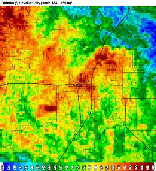
Below is the Elevation map of Quinlan, which displays elevation range with different colors. Scale of the first map is from 133 to 169 m (436 to 554 ft) with average elevation of 152.1 meters (=499 ft) [note 1]
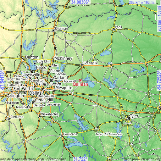
These maps also provides idea of topography and contour of this city, they are displayed at different zoom levels. More info about maps, scale and edge coordinates you can find below images.
| \ | Map #1 | Topo.Map |
| Scale [m] | 133..169 m | × |
| Scale [ft] | 436..554 ft | × |
| Average | 152.1 m = 499 ft | × |
| Width | 8.2 km = 5.1 mi | 262.5 km = 163.1 mi |
| Height | 8.2 km = 5.1 mi | 262.5 km = 163.1 mi |
| ↑Max Latitude | 32.947285° | 34.08306° |
| Latitude at center | 32.9104° | 32.9104° |
| ↓Min Latitude | 32.873499° | 31.722° |
| ← Min Longitude | -96.179475° | -97.54178° |
| Longitude center | -96.13553° | -96.13553° |
| →Max Longitude | -96.091585° | -94.72928° |
Nearby cities:
Cities around Quinlan sort by population:
• Rockwall elevation 184 m
30.3 km,  274°
274°
• Greenville 169 m
25.5 km,  5°
5°
• Terrell 158 m
23.4 km,  213°
213°
• Royse City 173 m
19.7 km,  291°
291°
• Fate 183 m
23.2 km,  278°
278°
• Wills Point 167 m
25.3 km,  151°
151°
• Lavon 163 m
30.8 km,  295°
295°
• McLendon-Chisholm 158 m
24.1 km,  251°
251°
• West Tawakoni 147 m
10.1 km,  100°
100°
• Caddo Mills 168 m
19.3 km,  333°
333°
• Josephine 182 m
23.2 km,  316°
316°
• Nevada 200 m
26.6 km, 303°
Multilingual:
 En español:
Quinlan elevación 161 m.
 En France:
Quinlan élévation 161 m.


Sources and notes:
- [note 1] Map square and city borders are not equal. Map elevation data is calculated only from area inside that square.
- [src 1] Elevation data from geonames database provided with same terms of usage.
- [src 2] The elevation map of Quinlan is generated using elevation data from NASA's 3 arcsec (90m) resolution SRTM data.
- [src 3] Base (background) map © OpenStreetMap contributors tiles are generated by Geofabrik and OpenTopoMap.
Copyright & License:
This Quinlan Elevation Map is licensed under CC BY-SA. You may reuse any part from this page, if you give a proper credit by linking to this URL:
 More info on terms of use page.