Greenville elevation
Greenville (Texas, Hunt County), United States elevation is 169 meters and Greenville elevation in feet is 554 ft above sea level [src 1]. Greenville is a seat of a second-order administrative division (feature code) with elevation that is 110 meters (361 ft) smaller than average city elevation in United States.
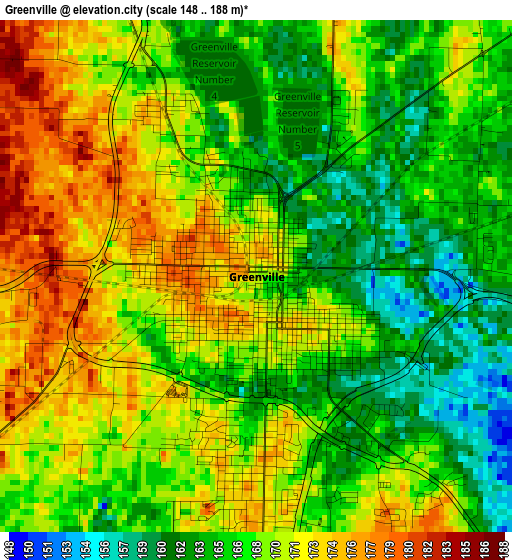
Below is the Elevation map of Greenville, which displays elevation range with different colors. Scale of the first map is from 148 to 188 m (486 to 617 ft) with average elevation of 168.1 meters (=552 ft) [note 1]
These maps also provides idea of topography and contour of this city, they are displayed at different zoom levels. More info about maps, scale and edge coordinates you can find below images.
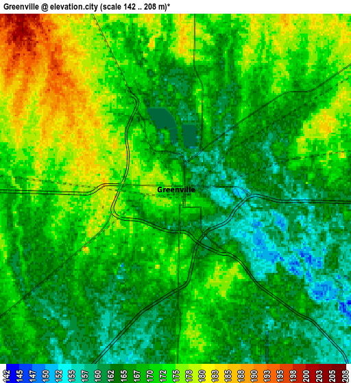
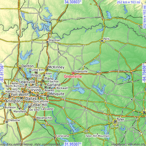
| \ | Map #1 | Map #2 | Topo.Map |
| Scale [m] | 148..188 m | 142..208 m | × |
| Scale [ft] | 486..617 ft | 466..682 ft | × |
| Average | 168.1 m = 552 ft | 169.4 m = 556 ft | × |
| Width | 8.18 km = 5.1 mi | 16.37 km = 10.2 mi | 261.8 km = 162.7 mi |
| Height | 8.18 km = 5.1 mi | 16.37 km = 10.2 mi | 261.8 km = 162.7 mi |
| ↑Max Latitude | 33.17524° | 33.212015° | 34.30803° |
| Latitude at center | 33.13845° | 33.13845° | 33.13845° |
| ↓Min Latitude | 33.101645° | 33.064824° | 31.95307° |
| ← Min Longitude | -96.154755° | -96.198701° | -97.51706° |
| Longitude center | -96.11081° | -96.11081° | -96.11081° |
| →Max Longitude | -96.066865° | -96.022919° | -94.70456° |
Nearby cities:
Cities around Greenville sort by population:
• Royse City elevation 173 m
27.5 km,  228°
228°
• Fate 183 m
33.4 km, 229°
• Commerce 172 m
23 km,  58°
58°
• Farmersville 203 m
23.4 km,  276°
276°
• Lavon 163 m
32.5 km,  247°
247°
• Leonard 221 m
29.7 km,  334°
334°
• West Tawakoni 147 m
28.2 km,  164°
164°
• Caddo Mills 168 m
13.6 km, 233°
• Quinlan 161 m
25.5 km,  185°
185°
• Wolfe City 215 m
26.1 km,  8°
8°
• Josephine 182 m
20.2 km,  244°
244°
• Nevada 200 m
26.7 km, 246°
Multilingual:
 En español:
Greenville elevación 169 m.
 En France:
Greenville élévation 169 m.
 Auf Deutsch:
Greenville höhe über dem Meeresspiegel ist 169 m.

Sources and notes:
- [note 1] Map square and city borders are not equal. Map elevation data is calculated only from area inside that square.
- [src 1] Elevation data from geonames database provided with same terms of usage.
- [src 2] The elevation map of Greenville is generated using elevation data from NASA's 3 arcsec (90m) resolution SRTM data.
- [src 3] Base (background) map © OpenStreetMap contributors tiles are generated by Geofabrik and OpenTopoMap.
Copyright & License:
This Greenville Elevation Map is licensed under CC BY-SA. You may reuse any part from this page, if you give a proper credit by linking to this URL:
 More info on terms of use page.