Anderson elevation
Anderson (Texas, Grimes County), United States elevation is 110 meters and Anderson elevation in feet is 361 ft above sea level [src 1]. Anderson is a seat of a second-order administrative division (feature code) with elevation that is 169 meters (554 ft) smaller than average city elevation in United States.
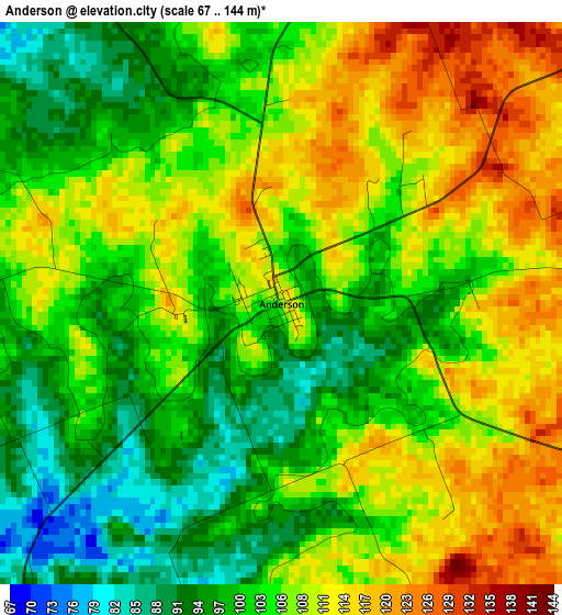
Below is the Elevation map of Anderson, which displays elevation range with different colors. Scale of the first map is from 67 to 144 m (220 to 472 ft) with average elevation of 105 meters (=344 ft) [note 1]
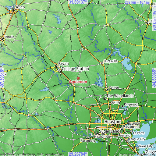
These maps also provides idea of topography and contour of this city, they are displayed at different zoom levels. More info about maps, scale and edge coordinates you can find below images.
| \ | Map #1 | Topo.Map |
| Scale [m] | 67..144 m | × |
| Scale [ft] | 220..472 ft | × |
| Average | 105 m = 344 ft | × |
| Width | 8.42 km = 5.2 mi | 269.5 km = 167.5 mi |
| Height | 8.42 km = 5.2 mi | 269.5 km = 167.5 mi |
| ↑Max Latitude | 30.525012° | 31.69137° |
| Latitude at center | 30.48715° | 30.48715° |
| ↓Min Latitude | 30.449273° | 29.26784° |
| ← Min Longitude | -96.030845° | -97.39315° |
| Longitude center | -95.9869° | -95.9869° |
| →Max Longitude | -95.942955° | -94.58065° |
Nearby cities:
Cities around Anderson sort by population:
• College Station elevation 107 m
36.8 km,  295°
295°
• Bryan 116 m
42.2 km, 299°
• Navasota 70 m
14.7 km,  221°
221°
• Hempstead 77 m
44.2 km,  191°
191°
• Prairie View 91 m
43.8 km,  180°
180°
• Willis 119 m
49.1 km,  98°
98°
• Pinehurst 69 m
45.7 km,  140°
140°
• Waller 77 m
48.2 km,  173°
173°
• Panorama Village 101 m
48.7 km, 104°
• Magnolia 84 m
38.3 km, 143°
• Pine Island 65 m
48 km, 185°
• New Waverly 111 m
48.6 km,  83°
83°
Multilingual:
 En español:
Anderson elevación 110 m.
 En France:
Anderson élévation 110 m.
 Auf Deutsch:
Anderson höhe über dem Meeresspiegel ist 110 m.

Sources and notes:
- [note 1] Map square and city borders are not equal. Map elevation data is calculated only from area inside that square.
- [src 1] Elevation data from geonames database provided with same terms of usage.
- [src 2] The elevation map of Anderson is generated using elevation data from NASA's 3 arcsec (90m) resolution SRTM data.
- [src 3] Base (background) map © OpenStreetMap contributors tiles are generated by Geofabrik and OpenTopoMap.
Copyright & License:
This Anderson Elevation Map is licensed under CC BY-SA. You may reuse any part from this page, if you give a proper credit by linking to this URL:
 More info on terms of use page.