Willis elevation
Willis (Texas, Montgomery County), United States elevation is 119 meters and Willis elevation in feet is 390 ft above sea level [src 1]. Willis is a populated place (feature code) with elevation that is 160 meters (525 ft) smaller than average city elevation in United States.
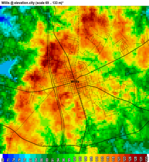
Below is the Elevation map of Willis, which displays elevation range with different colors. Scale of the first map is from 69 to 133 m (226 to 436 ft) with average elevation of 105 meters (=344 ft) [note 1]
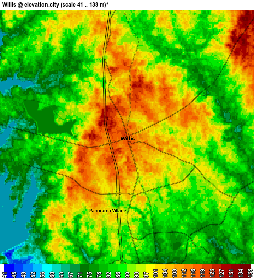
These maps also provides idea of topography and contour of this city, they are displayed at different zoom levels. More info about maps, scale and edge coordinates you can find below images.
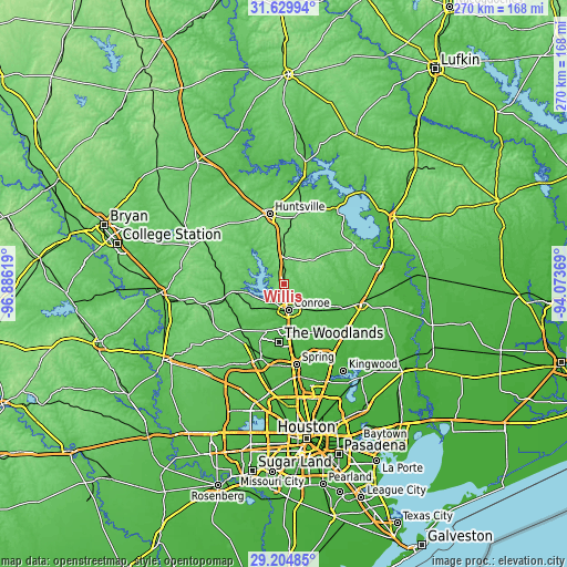
| \ | Map #1 | Map #2 | Topo.Map |
| Scale [m] | 69..133 m | 41..138 m | × |
| Scale [ft] | 226..436 ft | 135..453 ft | × |
| Average | 105 m = 344 ft | 91 m = 299 ft | × |
| Width | 8.43 km = 5.2 mi | 16.85 km = 10.5 mi | 269.6 km = 167.5 mi |
| Height | 8.43 km = 5.2 mi | 16.85 km = 10.5 mi | 269.7 km = 167.6 mi |
| ↑Max Latitude | 30.462816° | 30.500688° | 31.62994° |
| Latitude at center | 30.42493° | 30.42493° | 30.42493° |
| ↓Min Latitude | 30.387029° | 30.349113° | 29.20485° |
| ← Min Longitude | -95.523885° | -95.567831° | -96.88619° |
| Longitude center | -95.47994° | -95.47994° | -95.47994° |
| →Max Longitude | -95.435995° | -95.392049° | -94.07369° |
Nearby cities:
Cities around Willis sort by population:
• The Woodlands elevation 46 m
29.7 km,  181°
181°
• Conroe 69 m
12.8 km,  169°
169°
• Huntsville 116 m
33.9 km,  348°
348°
• Pinehurst 69 m
34.3 km,  214°
214°
• Oak Ridge North 49 m
29.6 km, 173°
• Shenandoah 50 m
27.3 km, 175°
• Panorama Village 101 m
5.1 km,  194°
194°
• Magnolia 84 m
35.4 km,  227°
227°
• Splendora 42 m
37.3 km,  124°
124°
• Porter Heights 40 m
33.9 km,  153°
153°
• Cut and Shoot 61 m
15.5 km,  131°
131°
• New Waverly 111 m
12.5 km,  358°
358°
Multilingual:
 En español:
Willis elevación 119 m.
 En France:
Willis élévation 119 m.


Sources and notes:
- [note 1] Map square and city borders are not equal. Map elevation data is calculated only from area inside that square.
- [src 1] Elevation data from geonames database provided with same terms of usage.
- [src 2] The elevation map of Willis is generated using elevation data from NASA's 3 arcsec (90m) resolution SRTM data.
- [src 3] Base (background) map © OpenStreetMap contributors tiles are generated by Geofabrik and OpenTopoMap.
Copyright & License:
This Willis Elevation Map is licensed under CC BY-SA. You may reuse any part from this page, if you give a proper credit by linking to this URL:
 More info on terms of use page.