The Woodlands elevation
The Woodlands (Texas, Montgomery County), United States elevation is 46 meters and The Woodlands elevation in feet is 151 ft above sea level [src 1]. The Woodlands is a populated place (feature code) with elevation that is 233 meters (764 ft) smaller than average city elevation in United States.
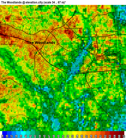
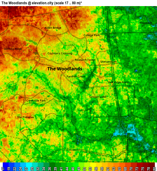
Below is the Elevation map of The Woodlands, which displays elevation range with different colors. Scale of the first map is from 34 to 67 m (112 to 220 ft) with average elevation of 50.3 meters (=165 ft) [note 1]
These maps also provides idea of topography and contour of this city, they are displayed at different zoom levels. More info about maps, scale and edge coordinates you can find below images.
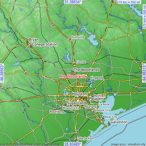
| \ | Map #1 | Map #2 | Topo.Map |
| Scale [m] | 34..67 m | 17..80 m | × |
| Scale [ft] | 112..220 ft | 56..262 ft | × |
| Average | 50.3 m = 165 ft | 50.8 m = 167 ft | × |
| Width | 8.45 km = 5.3 mi | 16.9 km = 10.5 mi | 270.4 km = 168 mi |
| Height | 8.45 km = 5.3 mi | 16.9 km = 10.5 mi | 270.4 km = 168 mi |
| ↑Max Latitude | 30.19598° | 30.233955° | 31.36634° |
| Latitude at center | 30.15799° | 30.15799° | 30.15799° |
| ↓Min Latitude | 30.119986° | 30.081967° | 28.93465° |
| ← Min Longitude | -95.533325° | -95.577271° | -96.89563° |
| Longitude center | -95.48938° | -95.48938° | -95.48938° |
| →Max Longitude | -95.445435° | -95.401489° | -94.08313° |
Nearby cities:
Cities around The Woodlands sort by population:
• Kingwood Area elevation 24 m
26 km,  122°
122°
• Conroe 69 m
17.4 km,  10°
10°
• Spring 38 m
11.1 km,  141°
141°
• Aldine 27 m
27.2 km,  157°
157°
• Tomball 59 m
13.9 km,  240°
240°
• Pinehurst 69 m
18.6 km,  274°
274°
• Oak Ridge North 49 m
4.3 km,  86°
86°
• Shenandoah 50 m
4.1 km,  52°
52°
• Panorama Village 101 m
24.8 km,  359°
359°
• Magnolia 84 m
25.8 km,  282°
282°
• Porter Heights 40 m
16.1 km, 92°
• Cut and Shoot 61 m
23.2 km,  32°
32°
Multilingual:
 En español:
The Woodlands elevación 46 m.
 En France:
The Woodlands élévation 46 m.
 Auf Deutsch:
The Woodlands höhe über dem Meeresspiegel ist 46 m.

Sources and notes:
- [note 1] Map square and city borders are not equal. Map elevation data is calculated only from area inside that square.
- [src 1] Elevation data from geonames database provided with same terms of usage.
- [src 2] The elevation map of The Woodlands is generated using elevation data from NASA's 3 arcsec (90m) resolution SRTM data.
- [src 3] Base (background) map © OpenStreetMap contributors tiles are generated by Geofabrik and OpenTopoMap.
Copyright & License:
This The Woodlands Elevation Map is licensed under CC BY-SA. You may reuse any part from this page, if you give a proper credit by linking to this URL:
 More info on terms of use page.