Sulphur elevation
Sulphur (Oklahoma, Murray County), United States elevation is 307 meters and Sulphur elevation in feet is 1007 ft above sea level [src 1]. Sulphur is a seat of a second-order administrative division (feature code) with elevation that is 28 meters (92 ft) bigger than average city elevation in United States.
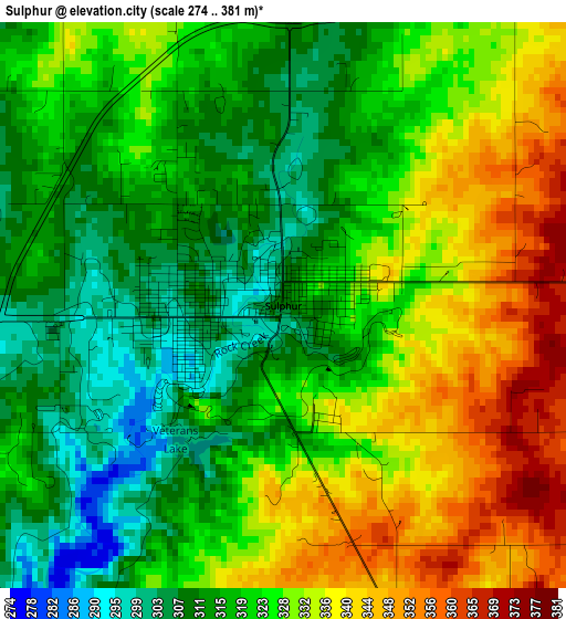
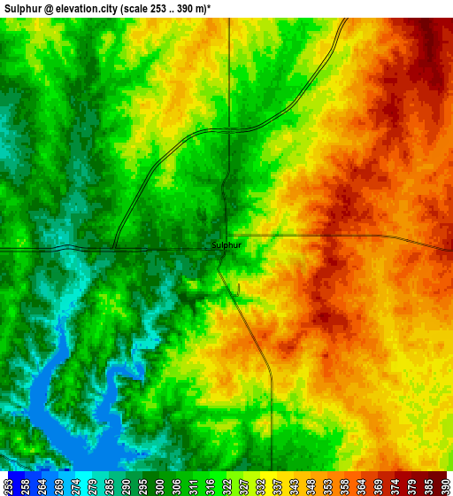
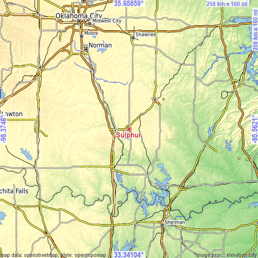
Below is the Elevation map of Sulphur, which displays elevation range with different colors. Scale of the first map is from 274 to 381 m (899 to 1250 ft) with average elevation of 324 meters (=1063 ft) [note 1]
These maps also provides idea of topography and contour of this city, they are displayed at different zoom levels. More info about maps, scale and edge coordinates you can find below images.
| \ | Map #1 | Map #2 | Topo.Map |
| Scale [m] | 274..381 m | 253..390 m | × |
| Scale [ft] | 899..1250 ft | 830..1280 ft | × |
| Average | 324 m = 1063 ft | 324.5 m = 1065 ft | × |
| Width | 8.05 km = 5 mi | 16.11 km = 10 mi | 257.7 km = 160.1 mi |
| Height | 8.05 km = 5 mi | 16.11 km = 10 mi | 257.7 km = 160.1 mi |
| ↑Max Latitude | 34.544075° | 34.580265° | 35.65859° |
| Latitude at center | 34.50787° | 34.50787° | 34.50787° |
| ↓Min Latitude | 34.471649° | 34.435412° | 33.34104° |
| ← Min Longitude | -97.012295° | -97.056241° | -98.3746° |
| Longitude center | -96.96835° | -96.96835° | -96.96835° |
| →Max Longitude | -96.924405° | -96.880459° | -95.5621° |
Nearby cities:
Cities around Sulphur sort by population:
• Ardmore elevation 267 m
40.4 km,  203°
203°
• Ada 314 m
39.8 km,  41°
41°
• Pauls Valley 273 m
34.7 km,  318°
318°
• Lone Grove 295 m
45.8 km,  216°
216°
• Madill 244 m
49.8 km,  158°
158°
• Tishomingo 207 m
40.2 km,  138°
138°
• Davis 263 m
13.9 km,  268°
268°
• Wynnewood 285 m
23.4 km,  310°
310°
• Stratford 346 m
32.1 km,  1°
1°
• Dickson 254 m
35.7 km,  182°
182°
• Byng 299 m
48.1 km, 35°
• Oakland 251 m
48.1 km, 160°
Multilingual:
 En español:
Sulphur elevación 307 m.
 En France:
Sulphur élévation 307 m.


Sources and notes:
- [note 1] Map square and city borders are not equal. Map elevation data is calculated only from area inside that square.
- [src 1] Elevation data from geonames database provided with same terms of usage.
- [src 2] The elevation map of Sulphur is generated using elevation data from NASA's 3 arcsec (90m) resolution SRTM data.
- [src 3] Base (background) map © OpenStreetMap contributors tiles are generated by Geofabrik and OpenTopoMap.
Copyright & License:
This Sulphur Elevation Map is licensed under CC BY-SA. You may reuse any part from this page, if you give a proper credit by linking to this URL:
 More info on terms of use page.