Sand Springs elevation
Sand Springs (Oklahoma, Tulsa County), United States elevation is 212 meters and Sand Springs elevation in feet is 696 ft above sea level [src 1]. Sand Springs is a populated place (feature code) with elevation that is 67 meters (220 ft) smaller than average city elevation in United States.
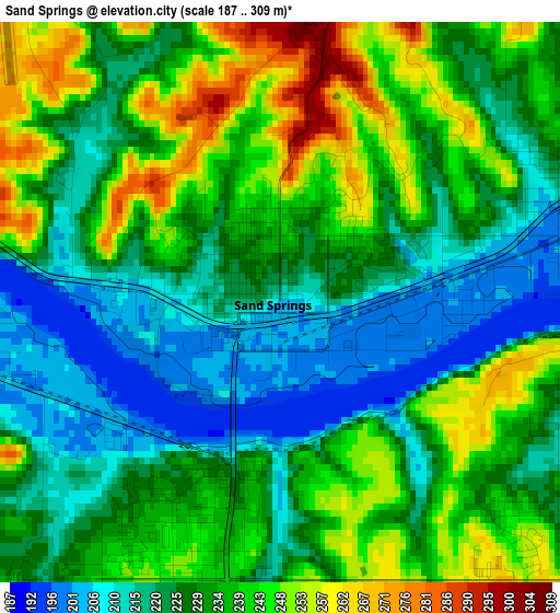
Below is the Elevation map of Sand Springs, which displays elevation range with different colors. Scale of the first map is from 187 to 309 m (614 to 1014 ft) with average elevation of 231 meters (=758 ft) [note 1]
These maps also provides idea of topography and contour of this city, they are displayed at different zoom levels. More info about maps, scale and edge coordinates you can find below images.
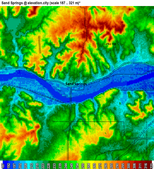
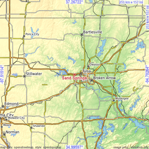
| \ | Map #1 | Map #2 | Topo.Map |
| Scale [m] | 187..309 m | 187..321 m | × |
| Scale [ft] | 614..1014 ft | 614..1053 ft | × |
| Average | 231 m = 758 ft | 240.2 m = 788 ft | × |
| Width | 7.89 km = 4.9 mi | 15.78 km = 9.8 mi | 252.5 km = 156.9 mi |
| Height | 7.89 km = 4.9 mi | 15.78 km = 9.8 mi | 252.5 km = 156.9 mi |
| ↑Max Latitude | 36.175291° | 36.210757° | 37.26722° |
| Latitude at center | 36.13981° | 36.13981° | 36.13981° |
| ↓Min Latitude | 36.104313° | 36.068799° | 34.99597° |
| ← Min Longitude | -96.152835° | -96.196781° | -97.51514° |
| Longitude center | -96.10889° | -96.10889° | -96.10889° |
| →Max Longitude | -96.064945° | -96.020999° | -94.70264° |
Nearby cities:
Cities around Sand Springs sort by population:
• Tulsa elevation 226 m
10.5 km,  81°
81°
• Owasso 188 m
27 km,  57°
57°
• Jenks 191 m
18.1 km,  135°
135°
• Sapulpa 223 m
15.7 km,  181°
181°
• Glenpool 219 m
22.4 km,  156°
156°
• Skiatook 198 m
27.2 km,  20°
20°
• Mannford 229 m
22.1 km,  268°
268°
• Turley 198 m
16.5 km,  46°
46°
• Oakhurst 237 m
8.2 km,  150°
150°
• Kiefer 216 m
22 km,  169°
169°
• Sperry 193 m
20.4 km,  31°
31°
• Kellyville 245 m
23.8 km,  203°
203°
Multilingual:
 En español:
Sand Springs elevación 212 m.
 En France:
Sand Springs élévation 212 m.
 Auf Deutsch:
Sand Springs höhe über dem Meeresspiegel ist 212 m.

Sources and notes:
- [note 1] Map square and city borders are not equal. Map elevation data is calculated only from area inside that square.
- [src 1] Elevation data from geonames database provided with same terms of usage.
- [src 2] The elevation map of Sand Springs is generated using elevation data from NASA's 3 arcsec (90m) resolution SRTM data.
- [src 3] Base (background) map © OpenStreetMap contributors tiles are generated by Geofabrik and OpenTopoMap.
Copyright & License:
This Sand Springs Elevation Map is licensed under CC BY-SA. You may reuse any part from this page, if you give a proper credit by linking to this URL:
 More info on terms of use page.