Tulsa elevation
Tulsa (Oklahoma, Tulsa County), United States elevation is 226 meters and Tulsa elevation in feet is 741 ft above sea level [src 1]. Tulsa is a seat of a second-order administrative division (feature code) with elevation that is 53 meters (174 ft) smaller than average city elevation in United States.
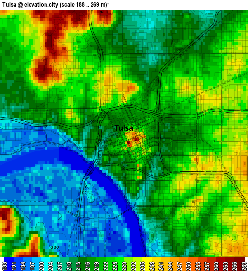
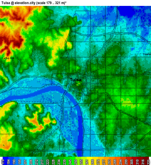
Below is the Elevation map of Tulsa, which displays elevation range with different colors. Scale of the first map is from 188 to 269 m (617 to 883 ft) with average elevation of 218.4 meters (=717 ft) [note 1]
These maps also provides idea of topography and contour of this city, they are displayed at different zoom levels. More info about maps, scale and edge coordinates you can find below images.
| \ | Map #1 | Map #2 | Topo.Map |
| Scale [m] | 188..269 m | 179..321 m | × |
| Scale [ft] | 617..883 ft | 587..1053 ft | × |
| Average | 218.4 m = 717 ft | 222.6 m = 730 ft | × |
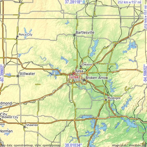
| Width | 7.89 km = 4.9 mi | 15.78 km = 9.8 mi | 252.5 km = 156.9 mi |
| Height | 7.89 km = 4.9 mi | 15.78 km = 9.8 mi | 252.5 km = 156.9 mi |
| ↑Max Latitude | 36.189455° | 36.224914° | 37.28118° |
| Latitude at center | 36.15398° | 36.15398° | 36.15398° |
| ↓Min Latitude | 36.118489° | 36.082982° | 35.01034° |
| ← Min Longitude | -96.036715° | -96.080661° | -97.39902° |
| Longitude center | -95.99277° | -95.99277° | -95.99277° |
| →Max Longitude | -95.948825° | -95.904879° | -94.58652° |
Nearby cities:
Cities around Tulsa sort by population:
• Broken Arrow elevation 234 m
21.4 km,  121°
121°
• Owasso 188 m
17.8 km,  43°
43°
• Jenks 191 m
14.7 km,  171°
171°
• Sapulpa 223 m
20.4 km,  212°
212°
• Sand Springs 212 m
10.5 km,  261°
261°
• Glenpool 219 m
22.1 km,  183°
183°
• Skiatook 198 m
23.9 km,  358°
358°
• Catoosa 193 m
22.5 km,  80°
80°
• Turley 198 m
9.9 km,  8°
8°
• Oakhurst 237 m
10.9 km,  216°
216°
• Kiefer 216 m
24.2 km,  195°
195°
• Sperry 193 m
15.9 km,  0°
0°
Multilingual:
 En español:
Tulsa elevación 226 m.
 En France:
Tulsa élévation 226 m.


Sources and notes:
- [note 1] Map square and city borders are not equal. Map elevation data is calculated only from area inside that square.
- [src 1] Elevation data from geonames database provided with same terms of usage.
- [src 2] The elevation map of Tulsa is generated using elevation data from NASA's 3 arcsec (90m) resolution SRTM data.
- [src 3] Base (background) map © OpenStreetMap contributors tiles are generated by Geofabrik and OpenTopoMap.
Copyright & License:
This Tulsa Elevation Map is licensed under CC BY-SA. You may reuse any part from this page, if you give a proper credit by linking to this URL:
 More info on terms of use page.