Mannford elevation
Mannford (Oklahoma, Creek County), United States elevation is 229 meters and Mannford elevation in feet is 751 ft above sea level [src 1]. Mannford is a populated place (feature code) with elevation that is 50 meters (164 ft) smaller than average city elevation in United States.
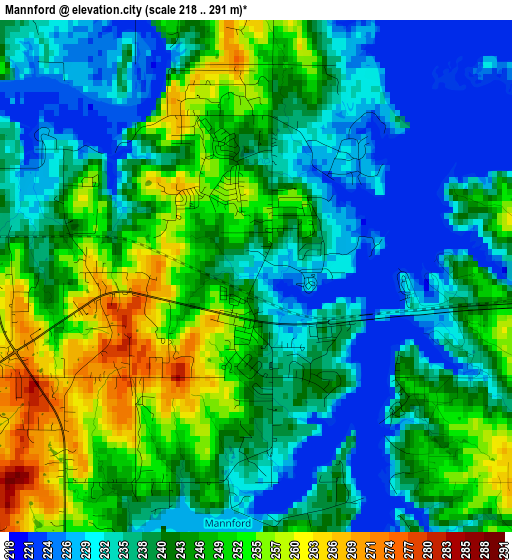
Below is the Elevation map of Mannford, which displays elevation range with different colors. Scale of the first map is from 218 to 291 m (715 to 955 ft) with average elevation of 241.6 meters (=793 ft) [note 1]
These maps also provides idea of topography and contour of this city, they are displayed at different zoom levels. More info about maps, scale and edge coordinates you can find below images.
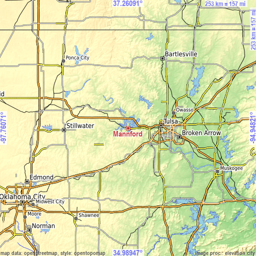
| \ | Map #1 | Topo.Map |
| Scale [m] | 218..291 m | × |
| Scale [ft] | 715..955 ft | × |
| Average | 241.6 m = 793 ft | × |
| Width | 7.89 km = 4.9 mi | 252.6 km = 157 mi |
| Height | 7.89 km = 4.9 mi | 252.6 km = 157 mi |
| ↑Max Latitude | 36.168894° | 37.26091° |
| Latitude at center | 36.13341° | 36.13341° |
| ↓Min Latitude | 36.09791° | 34.98947° |
| ← Min Longitude | -96.398405° | -97.76071° |
| Longitude center | -96.35446° | -96.35446° |
| →Max Longitude | -96.310515° | -94.94821° |
Nearby cities:
Cities around Mannford sort by population:
• Tulsa elevation 226 m
32.6 km,  85°
85°
• Sapulpa 223 m
26.3 km,  124°
124°
• Sand Springs 212 m
22.1 km, 88°
• Bristow 251 m
33.8 km,  185°
185°
• Hominy 244 m
31.4 km,  353°
353°
• Cleveland 234 m
22.1 km,  333°
333°
• Drumright 263 m
27.4 km,  233°
233°
• Oakhurst 237 m
26.8 km,  103°
103°
• Kiefer 216 m
33.4 km,  128°
128°
• Yale 250 m
31 km,  266°
266°
• Kellyville 245 m
24.6 km,  149°
149°
• Oilton 249 m
21.3 km,  255°
255°
Multilingual:
 En español:
Mannford elevación 229 m.
 En France:
Mannford élévation 229 m.
 Auf Deutsch:
Mannford höhe über dem Meeresspiegel ist 229 m.

Sources and notes:
- [note 1] Map square and city borders are not equal. Map elevation data is calculated only from area inside that square.
- [src 1] Elevation data from geonames database provided with same terms of usage.
- [src 2] The elevation map of Mannford is generated using elevation data from NASA's 3 arcsec (90m) resolution SRTM data.
- [src 3] Base (background) map © OpenStreetMap contributors tiles are generated by Geofabrik and OpenTopoMap.
Copyright & License:
This Mannford Elevation Map is licensed under CC BY-SA. You may reuse any part from this page, if you give a proper credit by linking to this URL:
 More info on terms of use page.