Sabina elevation
Sabina (Ohio, Clinton County), United States elevation is 321 meters and Sabina elevation in feet is 1053 ft above sea level [src 1]. Sabina is a populated place (feature code) with elevation that is 42 meters (138 ft) bigger than average city elevation in United States.
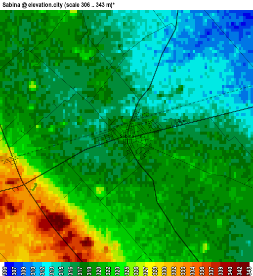
Below is the Elevation map of Sabina, which displays elevation range with different colors. Scale of the first map is from 306 to 343 m (1004 to 1125 ft) with average elevation of 319.1 meters (=1047 ft) [note 1]
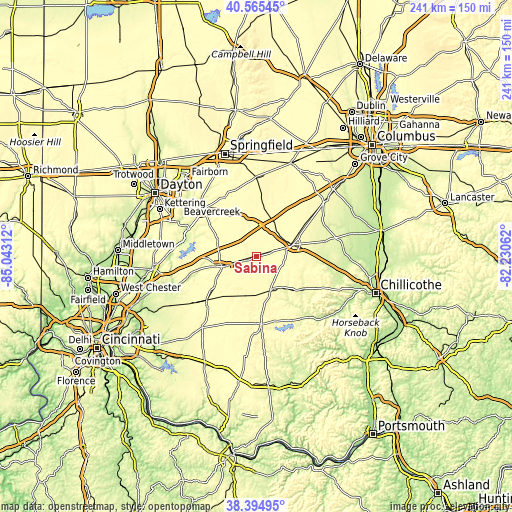
These maps also provides idea of topography and contour of this city, they are displayed at different zoom levels. More info about maps, scale and edge coordinates you can find below images.
| \ | Map #1 | Topo.Map |
| Scale [m] | 306..343 m | × |
| Scale [ft] | 1004..1125 ft | × |
| Average | 319.1 m = 1047 ft | × |
| Width | 7.54 km = 4.7 mi | 241.3 km = 149.9 mi |
| Height | 7.54 km = 4.7 mi | 241.3 km = 149.9 mi |
| ↑Max Latitude | 39.522577° | 40.56545° |
| Latitude at center | 39.48867° | 39.48867° |
| ↓Min Latitude | 39.454747° | 38.39495° |
| ← Min Longitude | -83.680815° | -85.04312° |
| Longitude center | -83.63687° | -83.63687° |
| →Max Longitude | -83.592925° | -82.23062° |
Nearby cities:
Cities around Sabina sort by population:
• Washington Court House elevation 300 m
17.8 km,  72°
72°
• Wilmington 311 m
17.1 km,  253°
253°
• Hillsboro 345 m
31.9 km,  176°
176°
• Greenfield 277 m
26.6 km,  124°
124°
• Cedarville 320 m
32 km,  332°
332°
• Wilberforce 309 m
32.6 km,  320°
320°
• Shawnee Hills 317 m
22.3 km, 324°
• Jamestown 323 m
20.6 km,  335°
335°
• Lynchburg 306 m
30.5 km,  205°
205°
• Leesburg 308 m
17.5 km,  155°
155°
• New Vienna 342 m
18.9 km,  194°
194°
• Jeffersonville 318 m
19.4 km,  18°
18°
Multilingual:
 En español:
Sabina elevación 321 m.
 En France:
Sabina élévation 321 m.


Sources and notes:
- [note 1] Map square and city borders are not equal. Map elevation data is calculated only from area inside that square.
- [src 1] Elevation data from geonames database provided with same terms of usage.
- [src 2] The elevation map of Sabina is generated using elevation data from NASA's 3 arcsec (90m) resolution SRTM data.
- [src 3] Base (background) map © OpenStreetMap contributors tiles are generated by Geofabrik and OpenTopoMap.
Copyright & License:
This Sabina Elevation Map is licensed under CC BY-SA. You may reuse any part from this page, if you give a proper credit by linking to this URL:
 More info on terms of use page.