Cedarville elevation
Cedarville (Ohio, Greene County), United States elevation is 320 meters and Cedarville elevation in feet is 1050 ft above sea level [src 1]. Cedarville is a populated place (feature code) with elevation that is 41 meters (135 ft) bigger than average city elevation in United States.
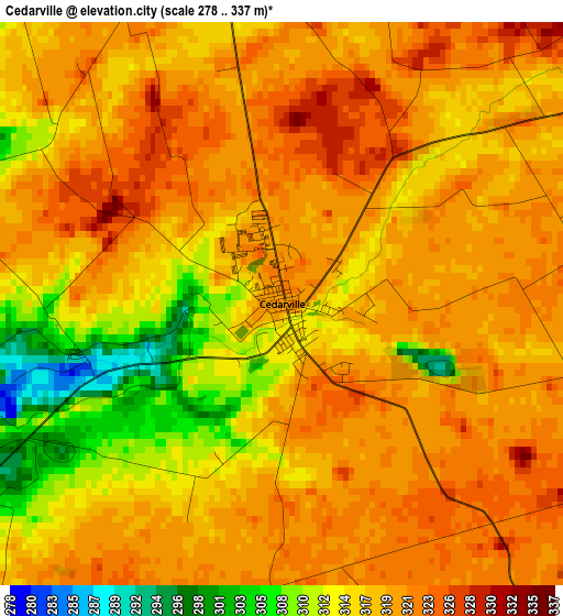
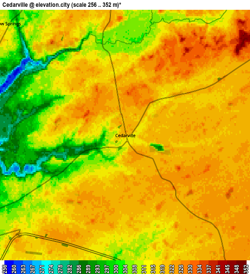
Below is the Elevation map of Cedarville, which displays elevation range with different colors. Scale of the first map is from 278 to 337 m (912 to 1106 ft) with average elevation of 317.7 meters (=1042 ft) [note 1]
These maps also provides idea of topography and contour of this city, they are displayed at different zoom levels. More info about maps, scale and edge coordinates you can find below images.
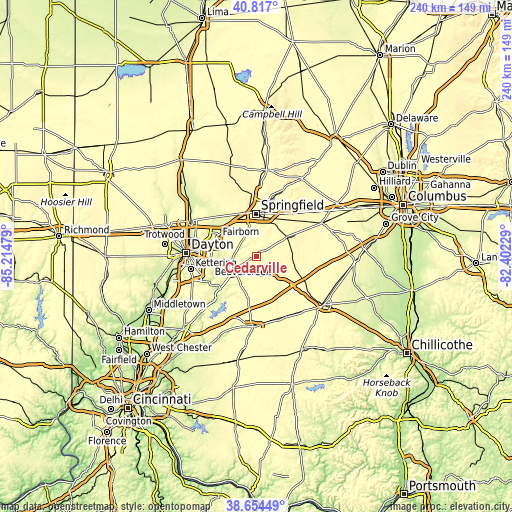
| \ | Map #1 | Map #2 | Topo.Map |
| Scale [m] | 278..337 m | 256..352 m | × |
| Scale [ft] | 912..1106 ft | 840..1155 ft | × |
| Average | 317.7 m = 1042 ft | 315 m = 1033 ft | × |
| Width | 7.51 km = 4.7 mi | 15.03 km = 9.3 mi | 240.4 km = 149.4 mi |
| Height | 7.51 km = 4.7 mi | 15.03 km = 9.3 mi | 240.4 km = 149.4 mi |
| ↑Max Latitude | 39.778012° | 39.811777° | 40.817° |
| Latitude at center | 39.74423° | 39.74423° | 39.74423° |
| ↓Min Latitude | 39.710432° | 39.676617° | 38.65449° |
| ← Min Longitude | -83.852485° | -83.896431° | -85.21479° |
| Longitude center | -83.80854° | -83.80854° | -83.80854° |
| →Max Longitude | -83.764595° | -83.720649° | -82.40229° |
Nearby cities:
Cities around Cedarville sort by population:
• Springfield elevation 305 m
20 km,  359°
359°
• Fairborn 255 m
19.9 km,  295°
295°
• Xenia 285 m
12.3 km,  237°
237°
• Yellow Springs 298 m
9.6 km,  315°
315°
• Lisbon 345 m
19.7 km,  48°
48°
• Enon 273 m
18.5 km, 323°
• Green Meadows 278 m
18.1 km, 320°
• Wilberforce 309 m
6.7 km, 242°
• Shawnee Hills 317 m
10.3 km,  169°
169°
• Jamestown 323 m
11.5 km,  146°
146°
• South Charleston 347 m
17.4 km,  58°
58°
• Holiday Valley 265 m
18.5 km,  312°
312°
Multilingual:
 En español:
Cedarville elevación 320 m.
 En France:
Cedarville élévation 320 m.
 Auf Deutsch:
Cedarville höhe über dem Meeresspiegel ist 320 m.

Sources and notes:
- [note 1] Map square and city borders are not equal. Map elevation data is calculated only from area inside that square.
- [src 1] Elevation data from geonames database provided with same terms of usage.
- [src 2] The elevation map of Cedarville is generated using elevation data from NASA's 3 arcsec (90m) resolution SRTM data.
- [src 3] Base (background) map © OpenStreetMap contributors tiles are generated by Geofabrik and OpenTopoMap.
Copyright & License:
This Cedarville Elevation Map is licensed under CC BY-SA. You may reuse any part from this page, if you give a proper credit by linking to this URL:
 More info on terms of use page.