Loveland elevation
Loveland (Ohio, Hamilton County), United States elevation is 184 meters and Loveland elevation in feet is 604 ft above sea level [src 1]. Loveland is a populated place (feature code) with elevation that is 95 meters (312 ft) smaller than average city elevation in United States.
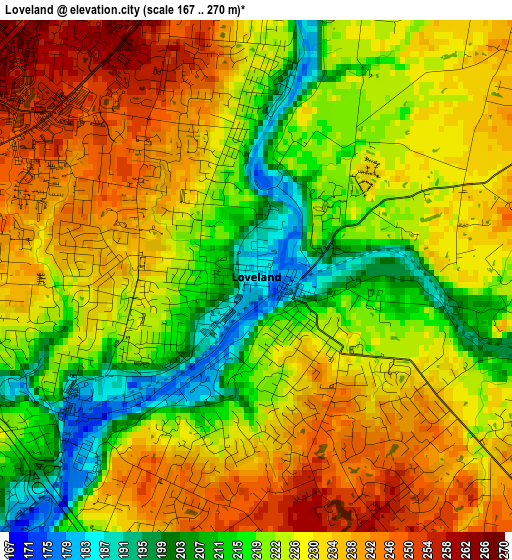
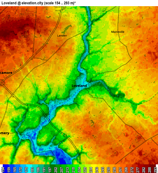
Below is the Elevation map of Loveland, which displays elevation range with different colors. Scale of the first map is from 167 to 270 m (548 to 886 ft) with average elevation of 226.3 meters (=742 ft) [note 1]
These maps also provides idea of topography and contour of this city, they are displayed at different zoom levels. More info about maps, scale and edge coordinates you can find below images.
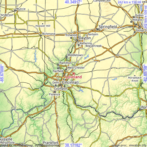
| \ | Map #1 | Map #2 | Topo.Map |
| Scale [m] | 167..270 m | 154..293 m | × |
| Scale [ft] | 548..886 ft | 505..961 ft | × |
| Average | 226.3 m = 742 ft | 239.1 m = 784 ft | × |
| Width | 7.57 km = 4.7 mi | 15.13 km = 9.4 mi | 242.1 km = 150.4 mi |
| Height | 7.57 km = 4.7 mi | 15.13 km = 9.4 mi | 242.1 km = 150.4 mi |
| ↑Max Latitude | 39.302963° | 39.33696° | 40.34917° |
| Latitude at center | 39.26895° | 39.26895° | 39.26895° |
| ↓Min Latitude | 39.23492° | 39.200874° | 38.17182° |
| ← Min Longitude | -84.307775° | -84.351721° | -85.67008° |
| Longitude center | -84.26383° | -84.26383° | -84.26383° |
| →Max Longitude | -84.219885° | -84.175939° | -82.85758° |
Nearby cities:
Cities around Loveland sort by population:
• Mason elevation 246 m
10.9 km,  338°
338°
• Blue Ash 260 m
10.7 km,  247°
247°
• Goshen 254 m
9.7 km,  114°
114°
• Montgomery 243 m
9 km,  239°
239°
• Milford 179 m
10.7 km,  194°
194°
• Landen 251 m
5.1 km, 340°
• Mount Repose 263 m
8.3 km,  155°
155°
• Mulberry 257 m
8.6 km,  167°
167°
• Sixteen Mile Stand 246 m
5.5 km,  274°
274°
• Loveland Park 225 m
3.4 km,  0°
0°
• Highpoint 268 m
7.7 km,  286°
286°
• Kings Mills 232 m
9.7 km,  7°
7°
Multilingual:
 En español:
Loveland elevación 184 m.
 En France:
Loveland élévation 184 m.
 Auf Deutsch:
Loveland höhe über dem Meeresspiegel ist 184 m.

Sources and notes:
- [note 1] Map square and city borders are not equal. Map elevation data is calculated only from area inside that square.
- [src 1] Elevation data from geonames database provided with same terms of usage.
- [src 2] The elevation map of Loveland is generated using elevation data from NASA's 3 arcsec (90m) resolution SRTM data.
- [src 3] Base (background) map © OpenStreetMap contributors tiles are generated by Geofabrik and OpenTopoMap.
Copyright & License:
This Loveland Elevation Map is licensed under CC BY-SA. You may reuse any part from this page, if you give a proper credit by linking to this URL:
 More info on terms of use page.