Randleman elevation
Randleman (North Carolina, Randolph County), United States elevation is 209 meters and Randleman elevation in feet is 686 ft above sea level [src 1]. Randleman is a populated place (feature code) with elevation that is 70 meters (230 ft) smaller than average city elevation in United States.
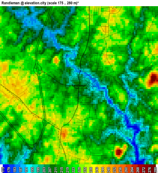
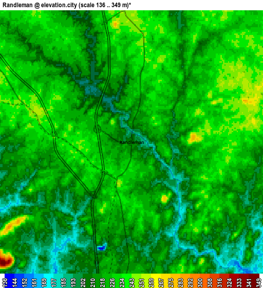
Below is the Elevation map of Randleman, which displays elevation range with different colors. Scale of the first map is from 175 to 280 m (574 to 919 ft) with average elevation of 217.7 meters (=714 ft) [note 1]
These maps also provides idea of topography and contour of this city, they are displayed at different zoom levels. More info about maps, scale and edge coordinates you can find below images.
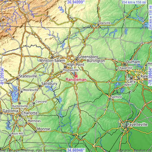
| \ | Map #1 | Map #2 | Topo.Map |
| Scale [m] | 175..280 m | 136..349 m | × |
| Scale [ft] | 574..919 ft | 446..1145 ft | × |
| Average | 217.7 m = 714 ft | 219.5 m = 720 ft | × |
| Width | 7.92 km = 4.9 mi | 15.85 km = 9.8 mi | 253.6 km = 157.6 mi |
| Height | 7.92 km = 4.9 mi | 15.85 km = 9.8 mi | 253.6 km = 157.6 mi |
| ↑Max Latitude | 35.853536° | 35.889147° | 36.94999° |
| Latitude at center | 35.81791° | 35.81791° | 35.81791° |
| ↓Min Latitude | 35.782268° | 35.746609° | 34.66946° |
| ← Min Longitude | -79.847035° | -79.890981° | -81.20934° |
| Longitude center | -79.80309° | -79.80309° | -79.80309° |
| →Max Longitude | -79.759145° | -79.715199° | -78.39684° |
Nearby cities:
Cities around Randleman sort by population:
• Greensboro elevation 260 m
28.3 km,  2°
2°
• High Point 289 m
23.8 km,  310°
310°
• Thomasville 260 m
26.1 km,  285°
285°
• Asheboro 256 m
12.3 km,  184°
184°
• Archdale 265 m
18.6 km, 305°
• Trinity 244 m
18.9 km,  296°
296°
• Pleasant Garden 261 m
16.4 km,  12°
12°
• Forest Oaks 234 m
20.8 km,  24°
24°
• Jamestown 239 m
22.9 km,  328°
328°
• Liberty 240 m
21.2 km,  79°
79°
• Ramseur 148 m
16.5 km,  124°
124°
• Franklinville 138 m
13 km,  129°
129°
Multilingual:
 En español:
Randleman elevación 209 m.
 En France:
Randleman élévation 209 m.
 Auf Deutsch:
Randleman höhe über dem Meeresspiegel ist 209 m.

Sources and notes:
- [note 1] Map square and city borders are not equal. Map elevation data is calculated only from area inside that square.
- [src 1] Elevation data from geonames database provided with same terms of usage.
- [src 2] The elevation map of Randleman is generated using elevation data from NASA's 3 arcsec (90m) resolution SRTM data.
- [src 3] Base (background) map © OpenStreetMap contributors tiles are generated by Geofabrik and OpenTopoMap.
Copyright & License:
This Randleman Elevation Map is licensed under CC BY-SA. You may reuse any part from this page, if you give a proper credit by linking to this URL:
 More info on terms of use page.