Liberty elevation
Liberty (North Carolina, Randolph County), United States elevation is 240 meters and Liberty elevation in feet is 787 ft above sea level [src 1]. Liberty is a populated place (feature code) with elevation that is 39 meters (128 ft) smaller than average city elevation in United States.
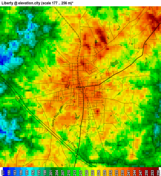
Below is the Elevation map of Liberty, which displays elevation range with different colors. Scale of the first map is from 177 to 256 m (581 to 840 ft) with average elevation of 219.9 meters (=721 ft) [note 1]
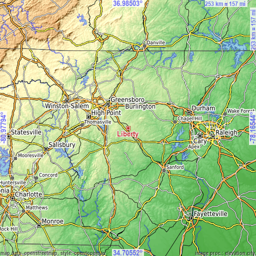
These maps also provides idea of topography and contour of this city, they are displayed at different zoom levels. More info about maps, scale and edge coordinates you can find below images.
| \ | Map #1 | Topo.Map |
| Scale [m] | 177..256 m | × |
| Scale [ft] | 581..840 ft | × |
| Average | 219.9 m = 721 ft | × |
| Width | 7.92 km = 4.9 mi | 253.5 km = 157.5 mi |
| Height | 7.92 km = 4.9 mi | 253.5 km = 157.5 mi |
| ↑Max Latitude | 35.88908° | 36.98503° |
| Latitude at center | 35.85347° | 35.85347° |
| ↓Min Latitude | 35.817844° | 34.70552° |
| ← Min Longitude | -79.615635° | -80.97794° |
| Longitude center | -79.57169° | -79.57169° |
| →Max Longitude | -79.527745° | -78.16544° |
Nearby cities:
Cities around Liberty sort by population:
• Asheboro elevation 256 m
27.2 km,  233°
233°
• Elon 217 m
28.3 km,  11°
11°
• Siler City 186 m
17.5 km,  145°
145°
• Gibsonville 220 m
28.2 km, 5°
• Pleasant Garden 261 m
21 km,  305°
305°
• Randleman 209 m
21.2 km,  259°
259°
• Forest Oaks 234 m
19.3 km,  321°
321°
• Ramseur 148 m
15.2 km,  208°
208°
• Saxapahaw 140 m
24.8 km,  65°
65°
• Swepsonville 158 m
26.6 km,  45°
45°
• Franklinville 138 m
16.3 km,  221°
221°
• Pleasant Hill 225 m
8.4 km, 74°
Multilingual:
 En español:
Liberty elevación 240 m.
 En France:
Liberty élévation 240 m.


Sources and notes:
- [note 1] Map square and city borders are not equal. Map elevation data is calculated only from area inside that square.
- [src 1] Elevation data from geonames database provided with same terms of usage.
- [src 2] The elevation map of Liberty is generated using elevation data from NASA's 3 arcsec (90m) resolution SRTM data.
- [src 3] Base (background) map © OpenStreetMap contributors tiles are generated by Geofabrik and OpenTopoMap.
Copyright & License:
This Liberty Elevation Map is licensed under CC BY-SA. You may reuse any part from this page, if you give a proper credit by linking to this URL:
 More info on terms of use page.