Greensboro elevation
Greensboro (North Carolina, Guilford County), United States elevation is 260 meters and Greensboro elevation in feet is 853 ft above sea level [src 1]. Greensboro is a populated place (feature code) with elevation that is 19 meters (62 ft) smaller than average city elevation in United States.
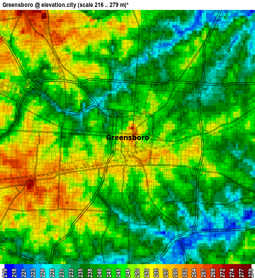
Below is the Elevation map of Greensboro, which displays elevation range with different colors. Scale of the first map is from 216 to 279 m (709 to 915 ft) with average elevation of 243.9 meters (=800 ft) [note 1]
These maps also provides idea of topography and contour of this city, they are displayed at different zoom levels. More info about maps, scale and edge coordinates you can find below images.
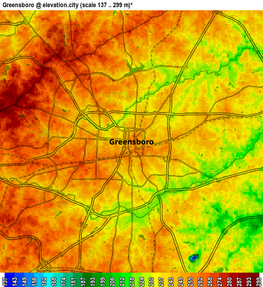
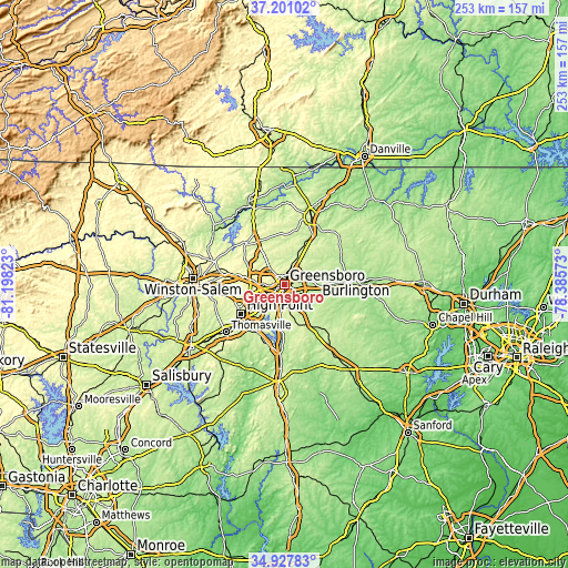
| \ | Map #1 | Map #2 | Topo.Map |
| Scale [m] | 216..279 m | 137..299 m | × |
| Scale [ft] | 709..915 ft | 449..981 ft | × |
| Average | 243.9 m = 800 ft | 246.5 m = 809 ft | × |
| Width | 7.9 km = 4.9 mi | 15.8 km = 9.8 mi | 252.8 km = 157.1 mi |
| Height | 7.9 km = 4.9 mi | 15.8 km = 9.8 mi | 252.8 km = 157.1 mi |
| ↑Max Latitude | 36.108152° | 36.143647° | 37.20102° |
| Latitude at center | 36.07264° | 36.07264° | 36.07264° |
| ↓Min Latitude | 36.037112° | 36.001568° | 34.92783° |
| ← Min Longitude | -79.835925° | -79.879871° | -81.19823° |
| Longitude center | -79.79198° | -79.79198° | -79.79198° |
| →Max Longitude | -79.748035° | -79.704089° | -78.38573° |
Nearby cities:
Cities around Greensboro sort by population:
• High Point elevation 289 m
23.2 km,  235°
235°
• Kernersville 307 m
25.8 km,  281°
281°
• Archdale 265 m
23.9 km,  222°
222°
• Summerfield 276 m
18.2 km,  326°
326°
• Elon 217 m
25.9 km,  82°
82°
• Gibsonville 220 m
22.7 km, 80°
• Oak Ridge 284 m
20.9 km,  302°
302°
• Stokesdale 289 m
24.9 km,  317°
317°
• Pleasant Garden 261 m
12.6 km,  167°
167°
• Forest Oaks 234 m
12.2 km,  140°
140°
• Jamestown 239 m
15.6 km, 235°
• McLeansville 231 m
12.6 km,  72°
72°
Multilingual:
 En español:
Greensboro elevación 260 m.
 En France:
Greensboro élévation 260 m.
 Auf Deutsch:
Greensboro höhe über dem Meeresspiegel ist 260 m.

Sources and notes:
- [note 1] Map square and city borders are not equal. Map elevation data is calculated only from area inside that square.
- [src 1] Elevation data from geonames database provided with same terms of usage.
- [src 2] The elevation map of Greensboro is generated using elevation data from NASA's 3 arcsec (90m) resolution SRTM data.
- [src 3] Base (background) map © OpenStreetMap contributors tiles are generated by Geofabrik and OpenTopoMap.
Copyright & License:
This Greensboro Elevation Map is licensed under CC BY-SA. You may reuse any part from this page, if you give a proper credit by linking to this URL:
 More info on terms of use page.