Belmont elevation
Belmont (Mississippi, Tishomingo County), United States elevation is 176 meters and Belmont elevation in feet is 577 ft above sea level [src 1]. Belmont is a populated place (feature code) with elevation that is 103 meters (338 ft) smaller than average city elevation in United States.
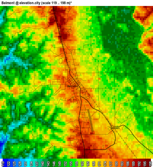
Below is the Elevation map of Belmont, which displays elevation range with different colors. Scale of the first map is from 119 to 198 m (390 to 650 ft) with average elevation of 161.1 meters (=529 ft) [note 1]
These maps also provides idea of topography and contour of this city, they are displayed at different zoom levels. More info about maps, scale and edge coordinates you can find below images.
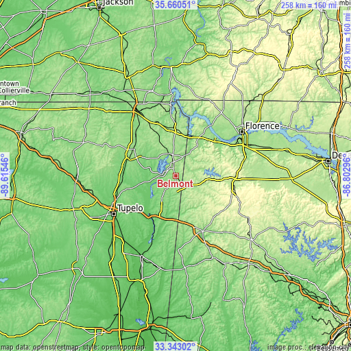
| \ | Map #1 | Topo.Map |
| Scale [m] | 119..198 m | × |
| Scale [ft] | 390..650 ft | × |
| Average | 161.1 m = 529 ft | × |
| Width | 8.05 km = 5 mi | 257.7 km = 160.1 mi |
| Height | 8.05 km = 5 mi | 257.7 km = 160.1 mi |
| ↑Max Latitude | 34.546024° | 35.66051° |
| Latitude at center | 34.50982° | 34.50982° |
| ↓Min Latitude | 34.4736° | 33.34302° |
| ← Min Longitude | -88.253155° | -89.61546° |
| Longitude center | -88.20921° | -88.20921° |
| →Max Longitude | -88.165265° | -86.80296° |
Nearby cities:
Cities around Belmont sort by population:
• Russellville elevation 234 m
44 km,  90°
90°
• Booneville 159 m
36.6 km,  296°
296°
• Hamilton 152 m
45.6 km,  153°
153°
• Saltillo 100 m
45.8 km,  251°
251°
• Fulton 106 m
32 km,  214°
214°
• Baldwyn 123 m
39 km,  269°
269°
• Red Bay 199 m
10 km,  141°
141°
• Iuka 176 m
33.6 km,  2°
2°
• Guntown 124 m
42 km,  259°
259°
• Hackleburg 286 m
43.4 km,  126°
126°
• Mantachie 109 m
33.1 km,  231°
231°
• Cherokee 161 m
35 km,  38°
38°
Multilingual:
 En español:
Belmont elevación 176 m.
 En France:
Belmont élévation 176 m.


Sources and notes:
- [note 1] Map square and city borders are not equal. Map elevation data is calculated only from area inside that square.
- [src 1] Elevation data from geonames database provided with same terms of usage.
- [src 2] The elevation map of Belmont is generated using elevation data from NASA's 3 arcsec (90m) resolution SRTM data.
- [src 3] Base (background) map © OpenStreetMap contributors tiles are generated by Geofabrik and OpenTopoMap.
Copyright & License:
This Belmont Elevation Map is licensed under CC BY-SA. You may reuse any part from this page, if you give a proper credit by linking to this URL:
 More info on terms of use page.