Saltillo elevation
Saltillo (Mississippi, Lee County), United States elevation is 100 meters and Saltillo elevation in feet is 328 ft above sea level [src 1]. Saltillo is a populated place (feature code) with elevation that is 179 meters (587 ft) smaller than average city elevation in United States.
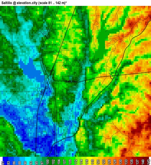
Below is the Elevation map of Saltillo, which displays elevation range with different colors. Scale of the first map is from 81 to 142 m (266 to 466 ft) with average elevation of 105.6 meters (=346 ft) [note 1]
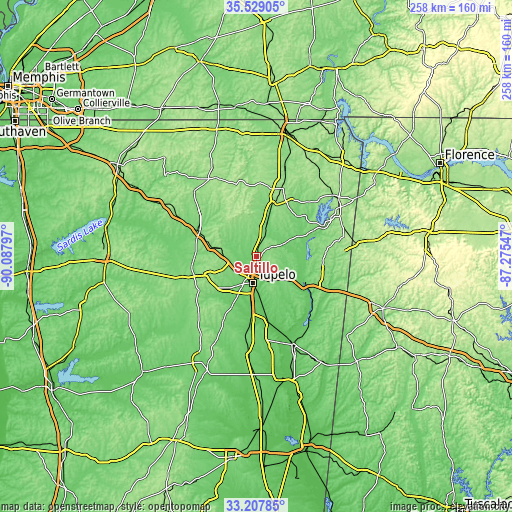
These maps also provides idea of topography and contour of this city, they are displayed at different zoom levels. More info about maps, scale and edge coordinates you can find below images.

| \ | Map #1 | Map #2 | Topo.Map |
| Scale [m] | 81..142 m | 77..164 m | × |
| Scale [ft] | 266..466 ft | 253..538 ft | × |
| Average | 105.6 m = 346 ft | 110.5 m = 363 ft | × |
| Width | 8.07 km = 5 mi | 16.13 km = 10 mi | 258.1 km = 160.4 mi |
| Height | 8.07 km = 5 mi | 16.13 km = 10 mi | 258.1 km = 160.4 mi |
| ↑Max Latitude | 34.412752° | 34.448999° | 35.52905° |
| Latitude at center | 34.37649° | 34.37649° | 34.37649° |
| ↓Min Latitude | 34.340212° | 34.303918° | 33.20785° |
| ← Min Longitude | -88.725665° | -88.769611° | -90.08797° |
| Longitude center | -88.68172° | -88.68172° | -88.68172° |
| →Max Longitude | -88.637775° | -88.593829° | -87.27547° |
Nearby cities:
Cities around Saltillo sort by population:
• Tupelo elevation 92 m
13.3 km,  189°
189°
• New Albany 111 m
32.6 km,  293°
293°
• Booneville 159 m
33 km,  18°
18°
• Pontotoc 154 m
32.4 km,  243°
243°
• Fulton 106 m
27.5 km,  114°
114°
• Baldwyn 123 m
15.4 km, 16°
• Verona 99 m
20.6 km, 189°
• Guntown 124 m
7.7 km, 15°
• Nettleton 80 m
32.4 km,  170°
170°
• Shannon 80 m
29.1 km, 185°
• Plantersville 98 m
18.2 km,  175°
175°
• Mantachie 109 m
18.4 km, 108°
Multilingual:
 En español:
Saltillo elevación 100 m.
 En France:
Saltillo élévation 100 m.
 Auf Deutsch:
Saltillo höhe über dem Meeresspiegel ist 100 m.

Sources and notes:
- [note 1] Map square and city borders are not equal. Map elevation data is calculated only from area inside that square.
- [src 1] Elevation data from geonames database provided with same terms of usage.
- [src 2] The elevation map of Saltillo is generated using elevation data from NASA's 3 arcsec (90m) resolution SRTM data.
- [src 3] Base (background) map © OpenStreetMap contributors tiles are generated by Geofabrik and OpenTopoMap.
Copyright & License:
This Saltillo Elevation Map is licensed under CC BY-SA. You may reuse any part from this page, if you give a proper credit by linking to this URL:
 More info on terms of use page.