Booneville elevation
Booneville (Mississippi, Prentiss County), United States elevation is 159 meters and Booneville elevation in feet is 522 ft above sea level [src 1]. Booneville is a seat of a second-order administrative division (feature code) with elevation that is 120 meters (394 ft) smaller than average city elevation in United States.
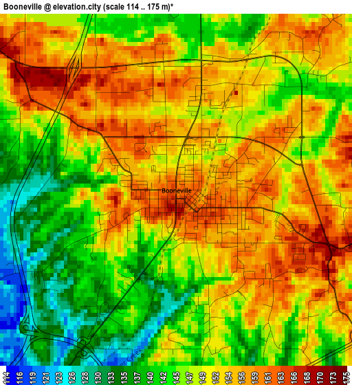
Below is the Elevation map of Booneville, which displays elevation range with different colors. Scale of the first map is from 114 to 175 m (374 to 574 ft) with average elevation of 148.9 meters (=489 ft) [note 1]
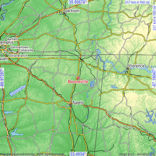
These maps also provides idea of topography and contour of this city, they are displayed at different zoom levels. More info about maps, scale and edge coordinates you can find below images.
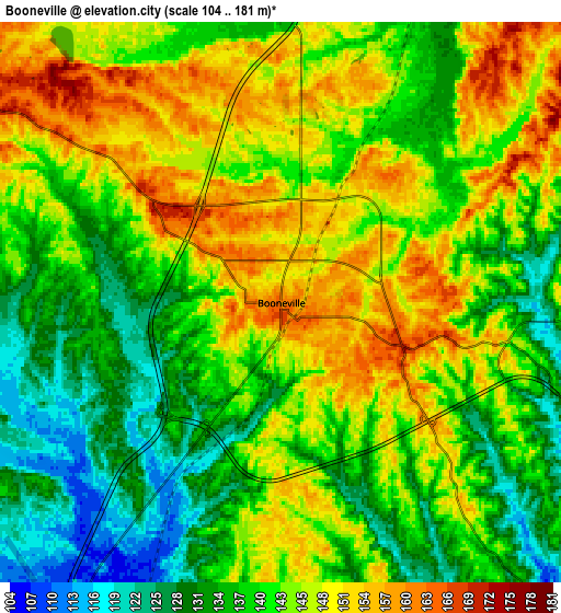
| \ | Map #1 | Map #2 | Topo.Map |
| Scale [m] | 114..175 m | 104..181 m | × |
| Scale [ft] | 374..574 ft | 341..594 ft | × |
| Average | 148.9 m = 489 ft | 141.8 m = 465 ft | × |
| Width | 8.04 km = 5 mi | 16.08 km = 10 mi | 257.2 km = 159.8 mi |
| Height | 8.04 km = 5 mi | 16.08 km = 10 mi | 257.2 km = 159.8 mi |
| ↑Max Latitude | 34.69429° | 34.730414° | 35.80676° |
| Latitude at center | 34.65815° | 34.65815° | 34.65815° |
| ↓Min Latitude | 34.621994° | 34.585823° | 33.4934° |
| ← Min Longitude | -88.610665° | -88.654611° | -89.97297° |
| Longitude center | -88.56672° | -88.56672° | -88.56672° |
| →Max Longitude | -88.522775° | -88.478829° | -87.16047° |
Nearby cities:
Cities around Booneville sort by population:
• Corinth elevation 133 m
31 km,  7°
7°
• New Albany 111 m
44.3 km,  245°
245°
• Ripley 152 m
36 km,  282°
282°
• Saltillo 100 m
33 km,  198°
198°
• Fulton 106 m
45.1 km,  161°
161°
• Baldwyn 123 m
17.7 km, 200°
• Red Bay 199 m
45.9 km,  121°
121°
• Iuka 176 m
38.4 km,  63°
63°
• Guntown 124 m
25.4 km, 199°
• Farmington 158 m
32 km,  19°
19°
• Belmont 176 m
36.6 km, 116°
• Mantachie 109 m
37.8 km,  169°
169°
Multilingual:
 En español:
Booneville elevación 159 m.
 En France:
Booneville élévation 159 m.
 Auf Deutsch:
Booneville höhe über dem Meeresspiegel ist 159 m.

Sources and notes:
- [note 1] Map square and city borders are not equal. Map elevation data is calculated only from area inside that square.
- [src 1] Elevation data from geonames database provided with same terms of usage.
- [src 2] The elevation map of Booneville is generated using elevation data from NASA's 3 arcsec (90m) resolution SRTM data.
- [src 3] Base (background) map © OpenStreetMap contributors tiles are generated by Geofabrik and OpenTopoMap.
Copyright & License:
This Booneville Elevation Map is licensed under CC BY-SA. You may reuse any part from this page, if you give a proper credit by linking to this URL:
 More info on terms of use page.