Tupelo elevation
Tupelo (Mississippi, Lee County), United States elevation is 92 meters and Tupelo elevation in feet is 302 ft above sea level [src 1]. Tupelo is a seat of a second-order administrative division (feature code) with elevation that is 187 meters (614 ft) smaller than average city elevation in United States.
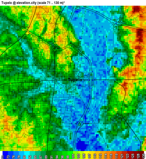
Below is the Elevation map of Tupelo, which displays elevation range with different colors. Scale of the first map is from 71 to 130 m (233 to 427 ft) with average elevation of 91.2 meters (=299 ft) [note 1]
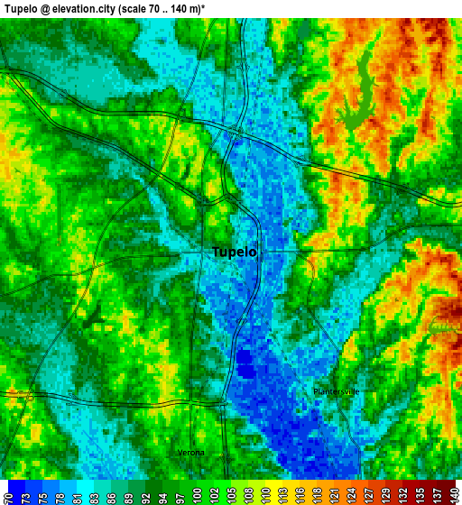
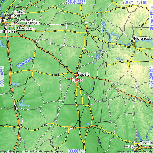
These maps also provides idea of topography and contour of this city, they are displayed at different zoom levels. More info about maps, scale and edge coordinates you can find below images.
| \ | Map #1 | Map #2 | Topo.Map |
| Scale [m] | 71..130 m | 70..140 m | × |
| Scale [ft] | 233..427 ft | 230..459 ft | × |
| Average | 91.2 m = 299 ft | 96 m = 315 ft | × |
| Width | 8.08 km = 5 mi | 16.15 km = 10 mi | 258.5 km = 160.6 mi |
| Height | 8.08 km = 5 mi | 16.15 km = 10 mi | 258.5 km = 160.6 mi |
| ↑Max Latitude | 34.294383° | 34.330681° | 35.41228° |
| Latitude at center | 34.25807° | 34.25807° | 34.25807° |
| ↓Min Latitude | 34.221741° | 34.185396° | 33.0878° |
| ← Min Longitude | -88.748585° | -88.792531° | -90.11089° |
| Longitude center | -88.70464° | -88.70464° | -88.70464° |
| →Max Longitude | -88.660695° | -88.616749° | -87.29839° |
Nearby cities:
Cities around Tupelo sort by population:
• Amory elevation 76 m
36.4 km,  146°
146°
• Pontotoc 154 m
27 km,  267°
267°
• Saltillo 100 m
13.3 km,  9°
9°
• Fulton 106 m
27.2 km,  86°
86°
• Baldwyn 123 m
28.7 km, 12°
• Verona 99 m
7.2 km,  191°
191°
• Okolona 104 m
28.9 km, 189°
• Guntown 124 m
21 km, 11°
• Nettleton 80 m
20.3 km,  158°
158°
• Shannon 80 m
15.8 km,  182°
182°
• Plantersville 98 m
6.2 km,  143°
143°
• Mantachie 109 m
20.9 km,  69°
69°
Multilingual:
 En español:
Tupelo elevación 92 m.
 En France:
Tupelo élévation 92 m.


Sources and notes:
- [note 1] Map square and city borders are not equal. Map elevation data is calculated only from area inside that square.
- [src 1] Elevation data from geonames database provided with same terms of usage.
- [src 2] The elevation map of Tupelo is generated using elevation data from NASA's 3 arcsec (90m) resolution SRTM data.
- [src 3] Base (background) map © OpenStreetMap contributors tiles are generated by Geofabrik and OpenTopoMap.
Copyright & License:
This Tupelo Elevation Map is licensed under CC BY-SA. You may reuse any part from this page, if you give a proper credit by linking to this URL:
 More info on terms of use page.