Amory elevation
Amory (Mississippi, Monroe County), United States elevation is 76 meters and Amory elevation in feet is 249 ft above sea level [src 1]. Amory is a populated place (feature code) with elevation that is 203 meters (666 ft) smaller than average city elevation in United States.
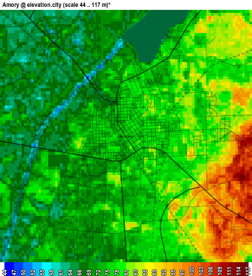
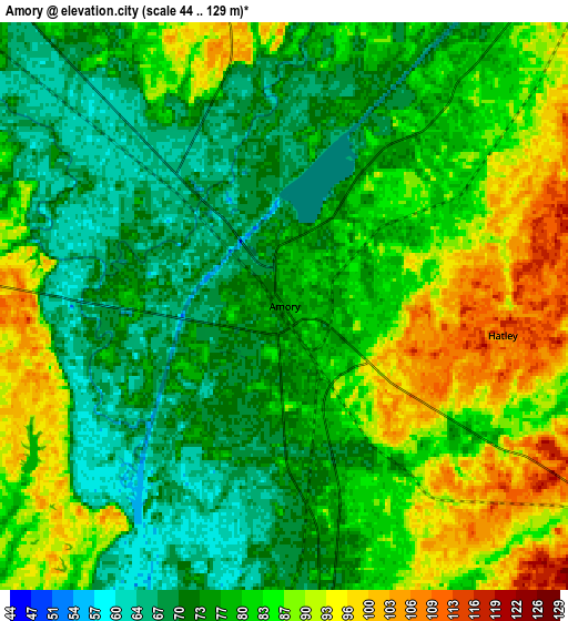
Below is the Elevation map of Amory, which displays elevation range with different colors. Scale of the first map is from 44 to 117 m (144 to 384 ft) with average elevation of 75.7 meters (=248 ft) [note 1]
These maps also provides idea of topography and contour of this city, they are displayed at different zoom levels. More info about maps, scale and edge coordinates you can find below images.
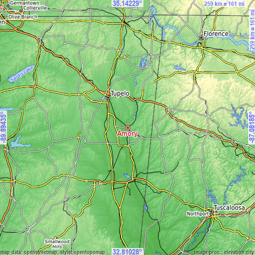
| \ | Map #1 | Map #2 | Topo.Map |
| Scale [m] | 44..117 m | 44..129 m | × |
| Scale [ft] | 144..384 ft | 144..423 ft | × |
| Average | 75.7 m = 248 ft | 80.2 m = 263 ft | × |
| Width | 8.1 km = 5 mi | 16.21 km = 10.1 mi | 259.3 km = 161.1 mi |
| Height | 8.1 km = 5 mi | 16.21 km = 10.1 mi | 259.3 km = 161.1 mi |
| ↑Max Latitude | 34.020711° | 34.057127° | 35.14229° |
| Latitude at center | 33.98428° | 33.98428° | 33.98428° |
| ↓Min Latitude | 33.947833° | 33.911371° | 32.81028° |
| ← Min Longitude | -88.532045° | -88.575991° | -89.89435° |
| Longitude center | -88.4881° | -88.4881° | -88.4881° |
| →Max Longitude | -88.444155° | -88.400209° | -87.08185° |
Nearby cities:
Cities around Amory sort by population:
• Tupelo elevation 92 m
36.4 km,  326°
326°
• Aberdeen 71 m
18.4 km,  196°
196°
• Fulton 106 m
33 km,  12°
12°
• Verona 99 m
31.6 km,  317°
317°
• Okolona 104 m
24.7 km,  274°
274°
• Nettleton 80 m
17 km,  313°
313°
• Sulligent 100 m
33.9 km,  105°
105°
• Shannon 80 m
25.3 km, 305°
• Columbus Air Force Base 63 m
39.3 km,  175°
175°
• Plantersville 98 m
30.2 km, 327°
• Mantachie 109 m
37.8 km,  359°
359°
• Caledonia 102 m
36.8 km,  155°
155°
Multilingual:
 En español:
Amory elevación 76 m.
 En France:
Amory élévation 76 m.


Sources and notes:
- [note 1] Map square and city borders are not equal. Map elevation data is calculated only from area inside that square.
- [src 1] Elevation data from geonames database provided with same terms of usage.
- [src 2] The elevation map of Amory is generated using elevation data from NASA's 3 arcsec (90m) resolution SRTM data.
- [src 3] Base (background) map © OpenStreetMap contributors tiles are generated by Geofabrik and OpenTopoMap.
Copyright & License:
This Amory Elevation Map is licensed under CC BY-SA. You may reuse any part from this page, if you give a proper credit by linking to this URL:
 More info on terms of use page.