Hackleburg elevation
Hackleburg (Alabama, Marion County), United States elevation is 286 meters and Hackleburg elevation in feet is 938 ft above sea level [src 1]. Hackleburg is a populated place (feature code) with elevation that is 7 meters (23 ft) bigger than average city elevation in United States.
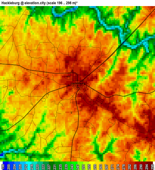
Below is the Elevation map of Hackleburg, which displays elevation range with different colors. Scale of the first map is from 196 to 298 m (643 to 978 ft) with average elevation of 262.4 meters (=861 ft) [note 1]
These maps also provides idea of topography and contour of this city, they are displayed at different zoom levels. More info about maps, scale and edge coordinates you can find below images.
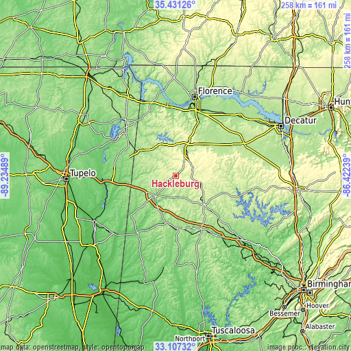
| \ | Map #1 | Topo.Map |
| Scale [m] | 196..298 m | × |
| Scale [ft] | 643..978 ft | × |
| Average | 262.4 m = 861 ft | × |
| Width | 8.08 km = 5 mi | 258.4 km = 160.6 mi |
| Height | 8.08 km = 5 mi | 258.4 km = 160.6 mi |
| ↑Max Latitude | 34.313625° | 35.43126° |
| Latitude at center | 34.27732° | 34.27732° |
| ↓Min Latitude | 34.240999° | 33.10732° |
| ← Min Longitude | -87.872585° | -89.23489° |
| Longitude center | -87.82864° | -87.82864° |
| →Max Longitude | -87.784695° | -86.42239° |
Nearby cities:
Cities around Hackleburg sort by population:
• Russellville elevation 234 m
27.2 km,  19°
19°
• Hamilton 152 m
21 km,  224°
224°
• Winfield 145 m
38.7 km,  178°
178°
• Haleyville 288 m
19.9 km,  106°
106°
• Red Bay 199 m
33.9 km,  302°
302°
• Guin 137 m
35.5 km,  192°
192°
• Belmont 176 m
43.4 km,  306°
306°
• Carbon Hill 147 m
51.1 km,  146°
146°
• Sulligent 100 m
50.4 km,  213°
213°
• Phil Campbell 313 m
13.9 km,  53°
53°
• Double Springs 253 m
41.8 km, 110°
• Bear Creek 248 m
11.8 km,  91°
91°
Multilingual:
 En español:
Hackleburg elevación 286 m.
 En France:
Hackleburg élévation 286 m.
 Auf Deutsch:
Hackleburg höhe über dem Meeresspiegel ist 286 m.

Sources and notes:
- [note 1] Map square and city borders are not equal. Map elevation data is calculated only from area inside that square.
- [src 1] Elevation data from geonames database provided with same terms of usage.
- [src 2] The elevation map of Hackleburg is generated using elevation data from NASA's 3 arcsec (90m) resolution SRTM data.
- [src 3] Base (background) map © OpenStreetMap contributors tiles are generated by Geofabrik and OpenTopoMap.
Copyright & License:
This Hackleburg Elevation Map is licensed under CC BY-SA. You may reuse any part from this page, if you give a proper credit by linking to this URL:
 More info on terms of use page.