Belmont elevation
Belmont (Mississippi, Wayne County), United States elevation is 60 meters and Belmont elevation in feet is 197 ft above sea level [src 1]. Belmont is a populated place (feature code) with elevation that is 219 meters (719 ft) smaller than average city elevation in United States.
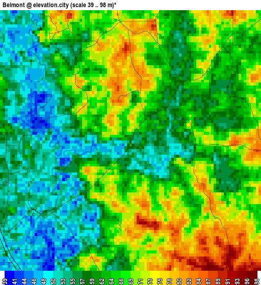
Below is the Elevation map of Belmont, which displays elevation range with different colors. Scale of the first map is from 39 to 98 m (128 to 322 ft) with average elevation of 63.3 meters (=208 ft) [note 1]
These maps also provides idea of topography and contour of this city, they are displayed at different zoom levels. More info about maps, scale and edge coordinates you can find below images.
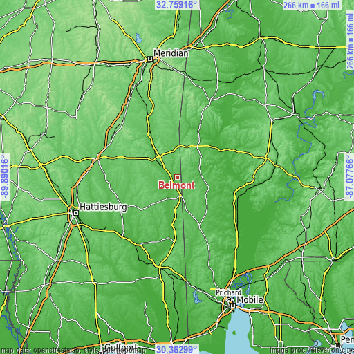
| \ | Map #1 | Topo.Map |
| Scale [m] | 39..98 m | × |
| Scale [ft] | 128..322 ft | × |
| Average | 63.3 m = 208 ft | × |
| Width | 8.33 km = 5.2 mi | 266.4 km = 165.5 mi |
| Height | 8.33 km = 5.2 mi | 266.4 km = 165.5 mi |
| ↑Max Latitude | 31.606204° | 32.75916° |
| Latitude at center | 31.56877° | 31.56877° |
| ↓Min Latitude | 31.531321° | 30.36299° |
| ← Min Longitude | -88.527855° | -89.89016° |
| Longitude center | -88.48391° | -88.48391° |
| →Max Longitude | -88.439965° | -87.07766° |
Nearby cities:
Cities around Belmont sort by population:
• Laurel elevation 89 m
62.8 km,  282°
282°
• Waynesboro 60 m
19.4 km,  307°
307°
• Jackson 69 m
56.3 km,  96°
96°
• Ellisville 81 m
67.5 km,  273°
273°
• Citronelle 97 m
58.4 km,  155°
155°
• Quitman 72 m
57.3 km,  336°
336°
• Butler 56 m
63 km,  23°
23°
• Sharon 97 m
63.1 km,  292°
292°
• Chatom 61 m
24.6 km,  117°
117°
• Richton 60 m
49.7 km,  240°
240°
• Leakesville 38 m
46.5 km,  188°
188°
• New Augusta 37 m
66.4 km,  232°
232°
Multilingual:
 En español:
Belmont elevación 60 m.
 En France:
Belmont élévation 60 m.


Sources and notes:
- [note 1] Map square and city borders are not equal. Map elevation data is calculated only from area inside that square.
- [src 1] Elevation data from geonames database provided with same terms of usage.
- [src 2] The elevation map of Belmont is generated using elevation data from NASA's 3 arcsec (90m) resolution SRTM data.
- [src 3] Base (background) map © OpenStreetMap contributors tiles are generated by Geofabrik and OpenTopoMap.
Copyright & License:
This Belmont Elevation Map is licensed under CC BY-SA. You may reuse any part from this page, if you give a proper credit by linking to this URL:
 More info on terms of use page.