Laurel elevation
Laurel (Mississippi, Jones County), United States elevation is 89 meters and Laurel elevation in feet is 292 ft above sea level [src 1]. Laurel is a populated place (feature code) with elevation that is 190 meters (623 ft) smaller than average city elevation in United States.
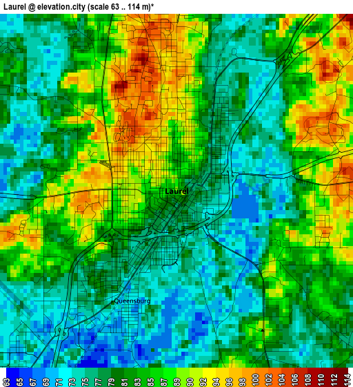
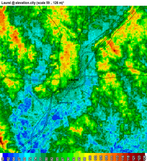
Below is the Elevation map of Laurel, which displays elevation range with different colors. Scale of the first map is from 63 to 114 m (207 to 374 ft) with average elevation of 81.7 meters (=268 ft) [note 1]
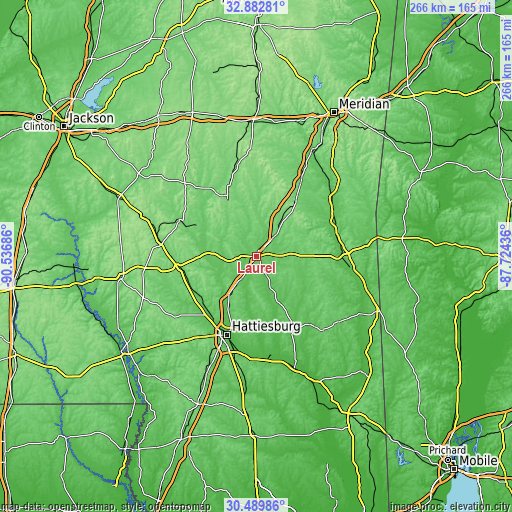
These maps also provides idea of topography and contour of this city, they are displayed at different zoom levels. More info about maps, scale and edge coordinates you can find below images.
| \ | Map #1 | Map #2 | Topo.Map |
| Scale [m] | 63..114 m | 59..126 m | × |
| Scale [ft] | 207..374 ft | 194..413 ft | × |
| Average | 81.7 m = 268 ft | 82.7 m = 271 ft | × |
| Width | 8.32 km = 5.2 mi | 16.63 km = 10.3 mi | 266.1 km = 165.3 mi |
| Height | 8.32 km = 5.2 mi | 16.63 km = 10.3 mi | 266.1 km = 165.3 mi |
| ↑Max Latitude | 31.731434° | 31.768803° | 32.88281° |
| Latitude at center | 31.69405° | 31.69405° | 31.69405° |
| ↓Min Latitude | 31.656651° | 31.619237° | 30.48986° |
| ← Min Longitude | -89.174555° | -89.218501° | -90.53686° |
| Longitude center | -89.13061° | -89.13061° | -89.13061° |
| →Max Longitude | -89.086665° | -89.042719° | -87.72436° |
Nearby cities:
Cities around Laurel sort by population:
• Hattiesburg elevation 54 m
43.5 km,  200°
200°
• Petal 52 m
40.5 km, 197°
• Waynesboro 60 m
45.9 km,  92°
92°
• Ellisville 81 m
11.7 km,  211°
211°
• Collins 89 m
40.6 km,  262°
262°
• Bay Springs 130 m
35 km,  334°
334°
• Arnold Line 73 m
46.1 km, 209°
• Glendale 56 m
40.2 km, 204°
• Sharon 97 m
11 km,  15°
15°
• Taylorsville 87 m
31.9 km,  298°
298°
• Rawls Springs 58 m
41.6 km, 213°
• Richton 60 m
42.4 km,  154°
154°
Multilingual:
 En español:
Laurel elevación 89 m.
 En France:
Laurel élévation 89 m.


Sources and notes:
- [note 1] Map square and city borders are not equal. Map elevation data is calculated only from area inside that square.
- [src 1] Elevation data from geonames database provided with same terms of usage.
- [src 2] The elevation map of Laurel is generated using elevation data from NASA's 3 arcsec (90m) resolution SRTM data.
- [src 3] Base (background) map © OpenStreetMap contributors tiles are generated by Geofabrik and OpenTopoMap.
Copyright & License:
This Laurel Elevation Map is licensed under CC BY-SA. You may reuse any part from this page, if you give a proper credit by linking to this URL:
 More info on terms of use page.