Petal elevation
Petal (Mississippi, Forrest County), United States elevation is 52 meters and Petal elevation in feet is 171 ft above sea level [src 1]. Petal is a populated place (feature code) with elevation that is 227 meters (745 ft) smaller than average city elevation in United States.
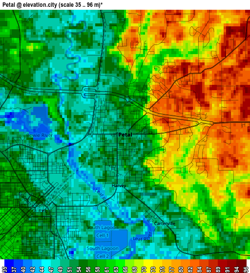
Below is the Elevation map of Petal, which displays elevation range with different colors. Scale of the first map is from 35 to 96 m (115 to 315 ft) with average elevation of 60.5 meters (=198 ft) [note 1]
These maps also provides idea of topography and contour of this city, they are displayed at different zoom levels. More info about maps, scale and edge coordinates you can find below images.
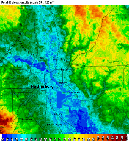
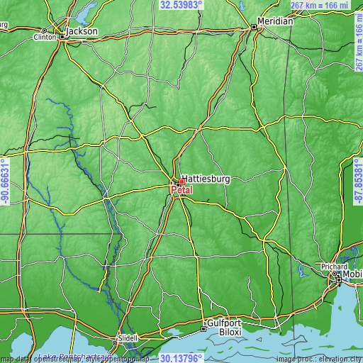
| \ | Map #1 | Map #2 | Topo.Map |
| Scale [m] | 35..96 m | 35..123 m | × |
| Scale [ft] | 115..315 ft | 115..404 ft | × |
| Average | 60.5 m = 198 ft | 67.2 m = 220 ft | × |
| Width | 8.35 km = 5.2 mi | 16.69 km = 10.4 mi | 267.1 km = 166 mi |
| Height | 8.35 km = 5.2 mi | 16.69 km = 10.4 mi | 267.1 km = 166 mi |
| ↑Max Latitude | 31.384083° | 31.421592° | 32.53983° |
| Latitude at center | 31.34656° | 31.34656° | 31.34656° |
| ↓Min Latitude | 31.309022° | 31.271468° | 30.13796° |
| ← Min Longitude | -89.304005° | -89.347951° | -90.66631° |
| Longitude center | -89.26006° | -89.26006° | -89.26006° |
| →Max Longitude | -89.216115° | -89.172169° | -87.85381° |
Nearby cities:
Cities around Petal sort by population:
• Hattiesburg elevation 54 m
3.6 km,  233°
233°
• Laurel 89 m
40.5 km,  17°
17°
• West Hattiesburg 85 m
11.3 km,  254°
254°
• Ellisville 81 m
29.3 km,  12°
12°
• Purvis 118 m
26.7 km,  212°
212°
• Lumberton 92 m
42.5 km, 205°
• Arnold Line 73 m
10.8 km,  263°
263°
• Sumrall 94 m
27.9 km,  286°
286°
• Glendale 56 m
4.8 km, 294°
• Rawls Springs 58 m
11.2 km, 289°
• Richton 60 m
30.4 km,  89°
89°
• New Augusta 37 m
26.6 km,  127°
127°
Multilingual:
 En español:
Petal elevación 52 m.
 En France:
Petal élévation 52 m.


Sources and notes:
- [note 1] Map square and city borders are not equal. Map elevation data is calculated only from area inside that square.
- [src 1] Elevation data from geonames database provided with same terms of usage.
- [src 2] The elevation map of Petal is generated using elevation data from NASA's 3 arcsec (90m) resolution SRTM data.
- [src 3] Base (background) map © OpenStreetMap contributors tiles are generated by Geofabrik and OpenTopoMap.
Copyright & License:
This Petal Elevation Map is licensed under CC BY-SA. You may reuse any part from this page, if you give a proper credit by linking to this URL:
 More info on terms of use page.