Citronelle elevation
Citronelle (Alabama, Mobile County), United States elevation is 97 meters and Citronelle elevation in feet is 318 ft above sea level [src 1]. Citronelle is a populated place (feature code) with elevation that is 182 meters (597 ft) smaller than average city elevation in United States.
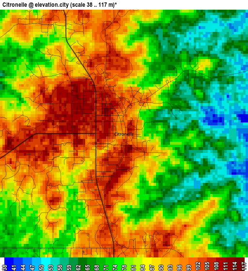
Below is the Elevation map of Citronelle, which displays elevation range with different colors. Scale of the first map is from 38 to 117 m (125 to 384 ft) with average elevation of 81.6 meters (=268 ft) [note 1]
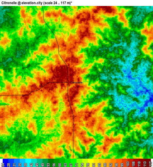
These maps also provides idea of topography and contour of this city, they are displayed at different zoom levels. More info about maps, scale and edge coordinates you can find below images.
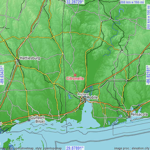
| \ | Map #1 | Map #2 | Topo.Map |
| Scale [m] | 38..117 m | 24..117 m | × |
| Scale [ft] | 125..384 ft | 79..384 ft | × |
| Average | 81.6 m = 268 ft | 72.9 m = 239 ft | × |
| Width | 8.37 km = 5.2 mi | 16.74 km = 10.4 mi | 267.8 km = 166.4 mi |
| Height | 8.37 km = 5.2 mi | 16.74 km = 10.4 mi | 267.8 km = 166.4 mi |
| ↑Max Latitude | 31.128355° | 31.165965° | 32.28729° |
| Latitude at center | 31.09073° | 31.09073° | 31.09073° |
| ↓Min Latitude | 31.05309° | 31.015435° | 29.87891° |
| ← Min Longitude | -88.272005° | -88.315951° | -89.63431° |
| Longitude center | -88.22806° | -88.22806° | -88.22806° |
| →Max Longitude | -88.184115° | -88.140169° | -86.82181° |
Nearby cities:
Cities around Citronelle sort by population:
• Mobile elevation 12 m
47.5 km,  158°
158°
• Prichard 14 m
41.6 km, 160°
• Saraland 9 m
33.6 km,  153°
153°
• Bay Minette 85 m
49.1 km,  118°
118°
• Satsuma 8 m
31.1 km, 148°
• Chickasaw 14 m
39.2 km, 158°
• Semmes 79 m
34.9 km,  184°
184°
• Lucedale 86 m
39.1 km,  241°
241°
• Creola 11 m
28.5 km,  140°
140°
• Mount Vernon 16 m
20.5 km,  91°
91°
• Chatom 61 m
41.7 km,  356°
356°
• Leakesville 38 m
32.2 km,  282°
282°
Multilingual:
 En español:
Citronelle elevación 97 m.
 En France:
Citronelle élévation 97 m.
 Auf Deutsch:
Citronelle höhe über dem Meeresspiegel ist 97 m.

Sources and notes:
- [note 1] Map square and city borders are not equal. Map elevation data is calculated only from area inside that square.
- [src 1] Elevation data from geonames database provided with same terms of usage.
- [src 2] The elevation map of Citronelle is generated using elevation data from NASA's 3 arcsec (90m) resolution SRTM data.
- [src 3] Base (background) map © OpenStreetMap contributors tiles are generated by Geofabrik and OpenTopoMap.
Copyright & License:
This Citronelle Elevation Map is licensed under CC BY-SA. You may reuse any part from this page, if you give a proper credit by linking to this URL:
 More info on terms of use page.