Lucedale elevation
Lucedale (Mississippi, George County), United States elevation is 86 meters and Lucedale elevation in feet is 282 ft above sea level [src 1]. Lucedale is a seat of a second-order administrative division (feature code) with elevation that is 193 meters (633 ft) smaller than average city elevation in United States.
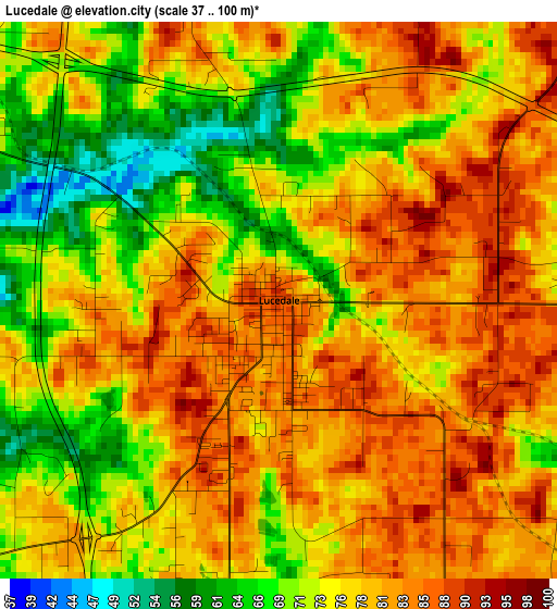
Below is the Elevation map of Lucedale, which displays elevation range with different colors. Scale of the first map is from 37 to 100 m (121 to 328 ft) with average elevation of 76.8 meters (=252 ft) [note 1]
These maps also provides idea of topography and contour of this city, they are displayed at different zoom levels. More info about maps, scale and edge coordinates you can find below images.
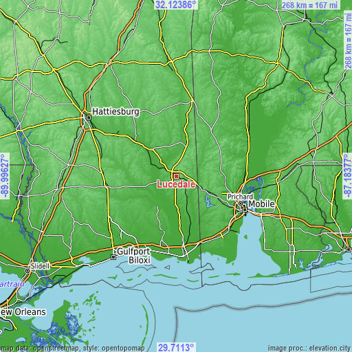
| \ | Map #1 | Topo.Map |
| Scale [m] | 37..100 m | × |
| Scale [ft] | 121..328 ft | × |
| Average | 76.8 m = 252 ft | × |
| Width | 8.38 km = 5.2 mi | 268.3 km = 166.7 mi |
| Height | 8.38 km = 5.2 mi | 268.3 km = 166.7 mi |
| ↑Max Latitude | 30.962881° | 32.12386° |
| Latitude at center | 30.92519° | 30.92519° |
| ↓Min Latitude | 30.887485° | 29.7113° |
| ← Min Longitude | -88.633965° | -89.99627° |
| Longitude center | -88.59002° | -88.59002° |
| →Max Longitude | -88.546075° | -87.18377° |
Nearby cities:
Cities around Lucedale sort by population:
• Saraland elevation 9 m
50.9 km,  103°
103°
• Satsuma 8 m
51.6 km, 98°
• Latimer 28 m
50.8 km,  211°
211°
• Chickasaw 14 m
52.4 km,  110°
110°
• Vancleave 15 m
43.8 km,  192°
192°
• Citronelle 97 m
39.1 km,  61°
61°
• Semmes 79 m
35.6 km,  117°
117°
• Hickory Hills 9 m
52.3 km, 185°
• Hurley 35 m
30.8 km,  162°
162°
• Helena 5 m
48.7 km,  169°
169°
• Wade 20 m
31.5 km,  176°
176°
• Leakesville 38 m
25.8 km,  6°
6°
Multilingual:
 En español:
Lucedale elevación 86 m.
 En France:
Lucedale élévation 86 m.


Sources and notes:
- [note 1] Map square and city borders are not equal. Map elevation data is calculated only from area inside that square.
- [src 1] Elevation data from geonames database provided with same terms of usage.
- [src 2] The elevation map of Lucedale is generated using elevation data from NASA's 3 arcsec (90m) resolution SRTM data.
- [src 3] Base (background) map © OpenStreetMap contributors tiles are generated by Geofabrik and OpenTopoMap.
Copyright & License:
This Lucedale Elevation Map is licensed under CC BY-SA. You may reuse any part from this page, if you give a proper credit by linking to this URL:
 More info on terms of use page.