Semmes elevation
Semmes (Alabama, Mobile County), United States elevation is 79 meters and Semmes elevation in feet is 259 ft above sea level [src 1]. Semmes is a populated place (feature code) with elevation that is 200 meters (656 ft) smaller than average city elevation in United States.
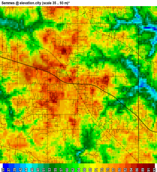
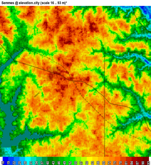
Below is the Elevation map of Semmes, which displays elevation range with different colors. Scale of the first map is from 35 to 93 m (115 to 305 ft) with average elevation of 68.2 meters (=224 ft) [note 1]
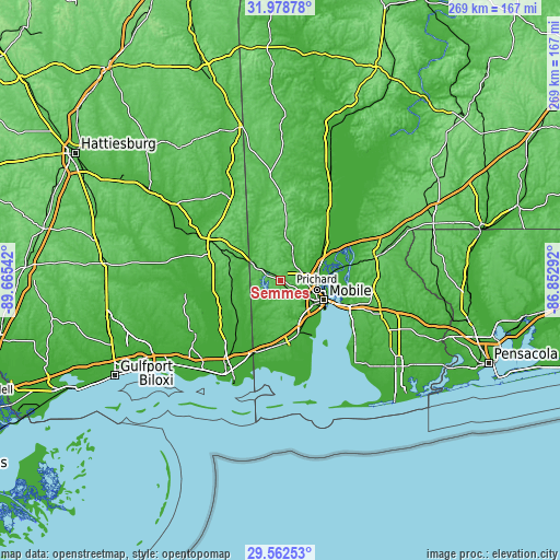
These maps also provides idea of topography and contour of this city, they are displayed at different zoom levels. More info about maps, scale and edge coordinates you can find below images.
| \ | Map #1 | Map #2 | Topo.Map |
| Scale [m] | 35..93 m | 16..93 m | × |
| Scale [ft] | 115..305 ft | 52..305 ft | × |
| Average | 68.2 m = 224 ft | 60.6 m = 199 ft | × |
| Width | 8.4 km = 5.2 mi | 16.79 km = 10.4 mi | 268.7 km = 167 mi |
| Height | 8.4 km = 5.2 mi | 16.79 km = 10.4 mi | 268.7 km = 167 mi |
| ↑Max Latitude | 30.815988° | 30.853722° | 31.97878° |
| Latitude at center | 30.77824° | 30.77824° | 30.77824° |
| ↓Min Latitude | 30.740477° | 30.702699° | 29.56253° |
| ← Min Longitude | -88.303115° | -88.347061° | -89.66542° |
| Longitude center | -88.25917° | -88.25917° | -88.25917° |
| →Max Longitude | -88.215225° | -88.171279° | -86.85292° |
Nearby cities:
Cities around Semmes sort by population:
• Mobile elevation 12 m
22.7 km,  114°
114°
• Prichard 14 m
17.8 km,  104°
104°
• Tillmans Corner 28 m
22.6 km,  158°
158°
• Saraland 9 m
18.6 km,  75°
75°
• Spanish Fort 19 m
34.8 km, 109°
• Satsuma 8 m
21.1 km,  66°
66°
• Theodore 22 m
26.9 km, 162°
• Chickasaw 14 m
17.7 km, 95°
• Grand Bay 30 m
34.5 km,  193°
193°
• Creola 11 m
24.5 km,  58°
58°
• Hurley 35 m
26 km,  239°
239°
• Wade 20 m
33.3 km, 243°
Multilingual:
 En español:
Semmes elevación 79 m.
 En France:
Semmes élévation 79 m.


Sources and notes:
- [note 1] Map square and city borders are not equal. Map elevation data is calculated only from area inside that square.
- [src 1] Elevation data from geonames database provided with same terms of usage.
- [src 2] The elevation map of Semmes is generated using elevation data from NASA's 3 arcsec (90m) resolution SRTM data.
- [src 3] Base (background) map © OpenStreetMap contributors tiles are generated by Geofabrik and OpenTopoMap.
Copyright & License:
This Semmes Elevation Map is licensed under CC BY-SA. You may reuse any part from this page, if you give a proper credit by linking to this URL:
 More info on terms of use page.