Carrollton elevation
Carrollton (Missouri, Carroll County), United States elevation is 232 meters and Carrollton elevation in feet is 761 ft above sea level [src 1]. Carrollton is a seat of a second-order administrative division (feature code) with elevation that is 47 meters (154 ft) smaller than average city elevation in United States.
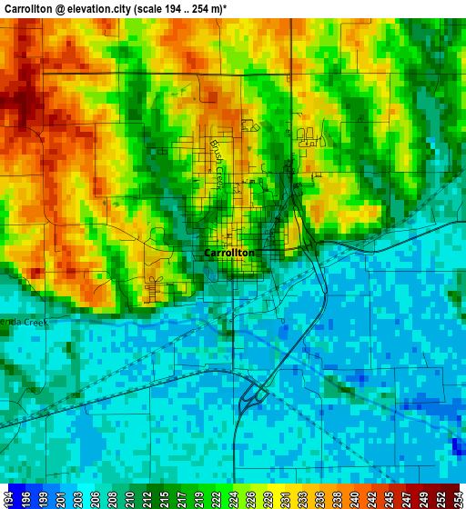
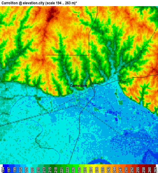
Below is the Elevation map of Carrollton, which displays elevation range with different colors. Scale of the first map is from 194 to 254 m (636 to 833 ft) with average elevation of 216.7 meters (=711 ft) [note 1]
These maps also provides idea of topography and contour of this city, they are displayed at different zoom levels. More info about maps, scale and edge coordinates you can find below images.
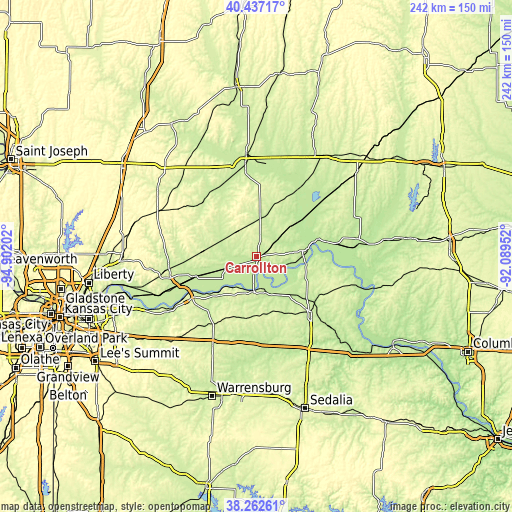
| \ | Map #1 | Map #2 | Topo.Map |
| Scale [m] | 194..254 m | 194..263 m | × |
| Scale [ft] | 636..833 ft | 636..863 ft | × |
| Average | 216.7 m = 711 ft | 219.7 m = 721 ft | × |
| Width | 7.56 km = 4.7 mi | 15.11 km = 9.4 mi | 241.8 km = 150.2 mi |
| Height | 7.56 km = 4.7 mi | 15.11 km = 9.4 mi | 241.8 km = 150.2 mi |
| ↑Max Latitude | 39.39232° | 39.426274° | 40.43717° |
| Latitude at center | 39.35835° | 39.35835° | 39.35835° |
| ↓Min Latitude | 39.324363° | 39.29036° | 38.26261° |
| ← Min Longitude | -93.539715° | -93.583661° | -94.90202° |
| Longitude center | -93.49577° | -93.49577° | -93.49577° |
| →Max Longitude | -93.451825° | -93.407879° | -92.08952° |
Nearby cities:
Cities around Carrollton sort by population:
• Marshall elevation 239 m
36.7 km,  135°
135°
• Chillicothe 244 m
48.8 km,  354°
354°
• Richmond 253 m
42.3 km,  257°
257°
• Odessa 288 m
56.1 km,  224°
224°
• Higginsville 252 m
37.1 km,  210°
210°
• Lexington 262 m
38.3 km,  239°
239°
• Concordia 243 m
42.2 km,  188°
188°
• Slater 266 m
39.9 km,  113°
113°
• Albany 228 m
55.2 km,  254°
254°
• Sweet Springs 223 m
44.4 km,  170°
170°
• Keytesville 221 m
48.6 km,  79°
79°
• Kingston 276 m
56.4 km,  304°
304°
Multilingual:
 En español:
Carrollton elevación 232 m.
 En France:
Carrollton élévation 232 m.
 Auf Deutsch:
Carrollton höhe über dem Meeresspiegel ist 232 m.

Sources and notes:
- [note 1] Map square and city borders are not equal. Map elevation data is calculated only from area inside that square.
- [src 1] Elevation data from geonames database provided with same terms of usage.
- [src 2] The elevation map of Carrollton is generated using elevation data from NASA's 3 arcsec (90m) resolution SRTM data.
- [src 3] Base (background) map © OpenStreetMap contributors tiles are generated by Geofabrik and OpenTopoMap.
Copyright & License:
This Carrollton Elevation Map is licensed under CC BY-SA. You may reuse any part from this page, if you give a proper credit by linking to this URL:
 More info on terms of use page.