Taneytown elevation
Taneytown (Maryland, Carroll County), United States elevation is 155 meters and Taneytown elevation in feet is 509 ft above sea level [src 1]. Taneytown is a populated place (feature code) with elevation that is 124 meters (407 ft) smaller than average city elevation in United States.
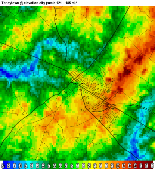
Below is the Elevation map of Taneytown, which displays elevation range with different colors. Scale of the first map is from 121 to 185 m (397 to 607 ft) with average elevation of 152.2 meters (=499 ft) [note 1]
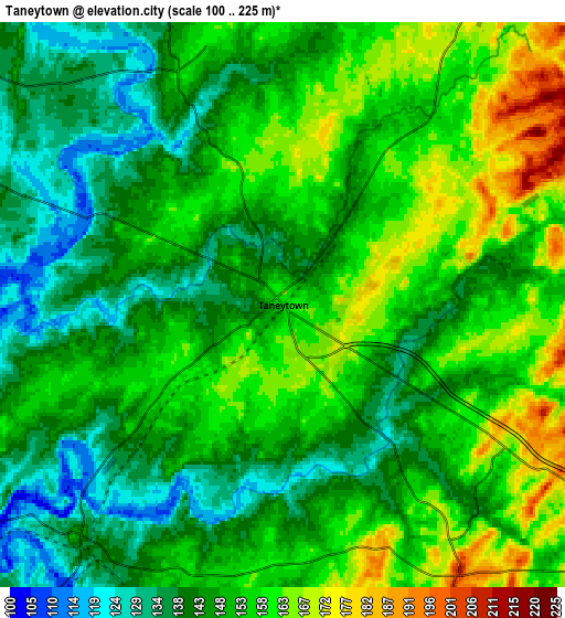
These maps also provides idea of topography and contour of this city, they are displayed at different zoom levels. More info about maps, scale and edge coordinates you can find below images.
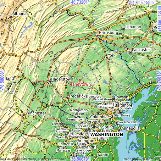
| \ | Map #1 | Map #2 | Topo.Map |
| Scale [m] | 121..185 m | 100..225 m | × |
| Scale [ft] | 397..607 ft | 328..738 ft | × |
| Average | 152.2 m = 499 ft | 150 m = 492 ft | × |
| Width | 7.52 km = 4.7 mi | 15.05 km = 9.4 mi | 240.7 km = 149.6 mi |
| Height | 7.52 km = 4.7 mi | 15.05 km = 9.4 mi | 240.7 km = 149.6 mi |
| ↑Max Latitude | 39.691704° | 39.725511° | 40.73201° |
| Latitude at center | 39.65788° | 39.65788° | 39.65788° |
| ↓Min Latitude | 39.62404° | 39.590183° | 38.56679° |
| ← Min Longitude | -77.218375° | -77.262321° | -78.58068° |
| Longitude center | -77.17443° | -77.17443° | -77.17443° |
| →Max Longitude | -77.130485° | -77.086539° | -75.76818° |
Nearby cities:
Cities around Taneytown sort by population:
• Westminster elevation 223 m
17.8 km,  120°
120°
• Gettysburg 166 m
19.8 km,  345°
345°
• Thurmont 157 m
20.6 km,  259°
259°
• Mount Pleasant 205 m
11.9 km,  45°
45°
• Littlestown 194 m
12.1 km,  37°
37°
• Carroll Valley 197 m
20.5 km,  299°
299°
• Emmitsburg 132 m
14 km,  291°
291°
• Pennville 171 m
21 km, 45°
• Bonneauville 173 m
17.4 km,  10°
10°
• New Windsor 143 m
14.1 km,  156°
156°
• Lake Heritage 147 m
16.9 km,  357°
357°
• Woodsboro 114 m
18.4 km,  220°
220°
Multilingual:
 En español:
Taneytown elevación 155 m.
 En France:
Taneytown élévation 155 m.
 Auf Deutsch:
Taneytown höhe über dem Meeresspiegel ist 155 m.

Sources and notes:
- [note 1] Map square and city borders are not equal. Map elevation data is calculated only from area inside that square.
- [src 1] Elevation data from geonames database provided with same terms of usage.
- [src 2] The elevation map of Taneytown is generated using elevation data from NASA's 3 arcsec (90m) resolution SRTM data.
- [src 3] Base (background) map © OpenStreetMap contributors tiles are generated by Geofabrik and OpenTopoMap.
Copyright & License:
This Taneytown Elevation Map is licensed under CC BY-SA. You may reuse any part from this page, if you give a proper credit by linking to this URL:
 More info on terms of use page.