Thurmont elevation
Thurmont (Maryland, Frederick County), United States elevation is 157 meters and Thurmont elevation in feet is 515 ft above sea level [src 1]. Thurmont is a populated place (feature code) with elevation that is 122 meters (400 ft) smaller than average city elevation in United States.
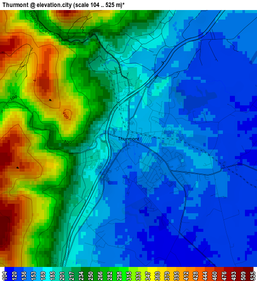
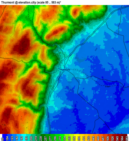
Below is the Elevation map of Thurmont, which displays elevation range with different colors. Scale of the first map is from 104 to 525 m (341 to 1722 ft) with average elevation of 215.6 meters (=707 ft) [note 1]
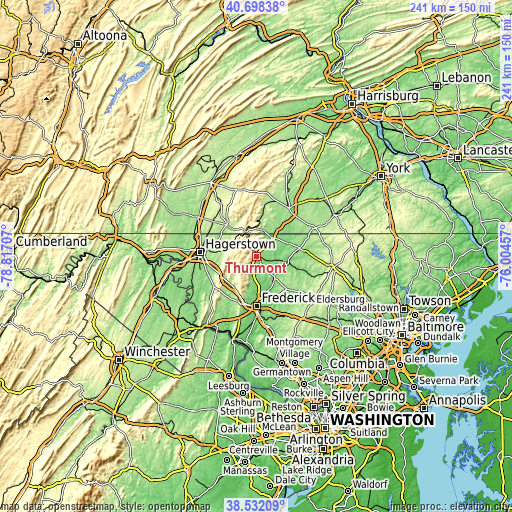
These maps also provides idea of topography and contour of this city, they are displayed at different zoom levels. More info about maps, scale and edge coordinates you can find below images.
| \ | Map #1 | Map #2 | Topo.Map |
| Scale [m] | 104..525 m | 85..583 m | × |
| Scale [ft] | 341..1722 ft | 279..1913 ft | × |
| Average | 215.6 m = 707 ft | 261.2 m = 857 ft | × |
| Width | 7.53 km = 4.7 mi | 15.05 km = 9.4 mi | 240.9 km = 149.7 mi |
| Height | 7.53 km = 4.7 mi | 15.05 km = 9.4 mi | 240.9 km = 149.7 mi |
| ↑Max Latitude | 39.657551° | 39.691375° | 40.69838° |
| Latitude at center | 39.62371° | 39.62371° | 39.62371° |
| ↓Min Latitude | 39.589853° | 39.555979° | 38.53209° |
| ← Min Longitude | -77.454765° | -77.498711° | -78.81707° |
| Longitude center | -77.41082° | -77.41082° | -77.41082° |
| →Max Longitude | -77.366875° | -77.322929° | -76.00457° |
Nearby cities:
Cities around Thurmont sort by population:
• Waynesboro elevation 218 m
20.5 km,  315°
315°
• Taneytown 155 m
20.6 km,  79°
79°
• Walkersville 97 m
16.1 km,  161°
161°
• Carroll Valley 197 m
14.2 km,  9°
9°
• Clover Hill 111 m
18.7 km,  184°
184°
• Emmitsburg 132 m
11.5 km,  38°
38°
• Smithsburg 234 m
14.3 km,  284°
284°
• Wayne Heights 194 m
18.1 km, 317°
• Myersville 206 m
18.8 km,  225°
225°
• Cavetown 220 m
15.2 km, 278°
• Woodsboro 114 m
13 km,  140°
140°
• Highfield-Cascade 426 m
12 km,  329°
329°
Multilingual:
 En español:
Thurmont elevación 157 m.
 En France:
Thurmont élévation 157 m.
 Auf Deutsch:
Thurmont höhe über dem Meeresspiegel ist 157 m.

Sources and notes:
- [note 1] Map square and city borders are not equal. Map elevation data is calculated only from area inside that square.
- [src 1] Elevation data from geonames database provided with same terms of usage.
- [src 2] The elevation map of Thurmont is generated using elevation data from NASA's 3 arcsec (90m) resolution SRTM data.
- [src 3] Base (background) map © OpenStreetMap contributors tiles are generated by Geofabrik and OpenTopoMap.
Copyright & License:
This Thurmont Elevation Map is licensed under CC BY-SA. You may reuse any part from this page, if you give a proper credit by linking to this URL:
 More info on terms of use page.