Plainville elevation
Plainville (Kansas, Rooks County), United States elevation is 659 meters and Plainville elevation in feet is 2162 ft above sea level [src 1]. Plainville is a populated place (feature code) with elevation that is 380 meters (1247 ft) bigger than average city elevation in United States.
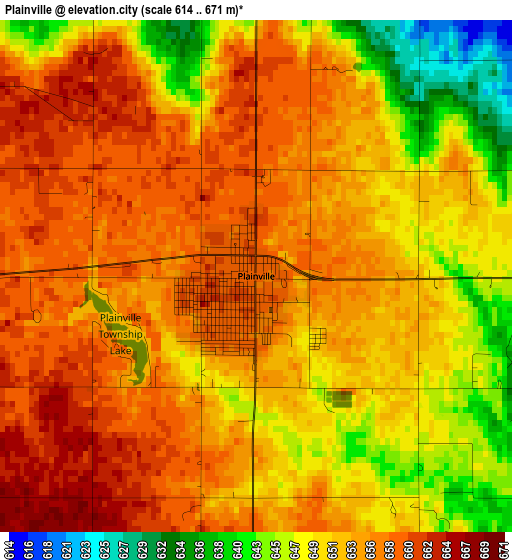
Below is the Elevation map of Plainville, which displays elevation range with different colors. Scale of the first map is from 614 to 671 m (2014 to 2201 ft) with average elevation of 653 meters (=2142 ft) [note 1]
These maps also provides idea of topography and contour of this city, they are displayed at different zoom levels. More info about maps, scale and edge coordinates you can find below images.
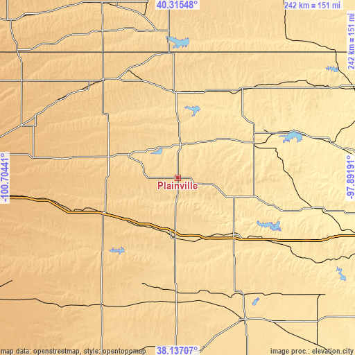
| \ | Map #1 | Topo.Map |
| Scale [m] | 614..671 m | × |
| Scale [ft] | 2014..2201 ft | × |
| Average | 653 m = 2142 ft | × |
| Width | 7.57 km = 4.7 mi | 242.2 km = 150.5 mi |
| Height | 7.57 km = 4.7 mi | 242.2 km = 150.5 mi |
| ↑Max Latitude | 39.26876° | 40.31548° |
| Latitude at center | 39.23473° | 39.23473° |
| ↓Min Latitude | 39.200683° | 38.13707° |
| ← Min Longitude | -99.342105° | -100.70441° |
| Longitude center | -99.29816° | -99.29816° |
| →Max Longitude | -99.254215° | -97.89191° |
Nearby cities:
Cities around Plainville sort by population:
• Hays elevation 624 m
39.6 km,  183°
183°
• Russell 563 m
53.4 km,  135°
135°
• Norton 713 m
83.8 km,  322°
322°
• Phillipsburg 599 m
58 km,  357°
357°
• Ellis 654 m
40 km,  214°
214°
• WaKeeney 754 m
55.3 km,  245°
245°
• Smith Center 549 m
74.8 km,  36°
36°
• Hill City 673 m
49 km,  287°
287°
• Osborne 478 m
56.5 km,  66°
66°
• Stockton 556 m
22.8 km,  7°
7°
• La Crosse 632 m
78.2 km, 180°
• Victoria 592 m
44.4 km,  162°
162°
Multilingual:
 En español:
Plainville elevación 659 m.
 En France:
Plainville élévation 659 m.
 Auf Deutsch:
Plainville höhe über dem Meeresspiegel ist 659 m.

Sources and notes:
- [note 1] Map square and city borders are not equal. Map elevation data is calculated only from area inside that square.
- [src 1] Elevation data from geonames database provided with same terms of usage.
- [src 2] The elevation map of Plainville is generated using elevation data from NASA's 3 arcsec (90m) resolution SRTM data.
- [src 3] Base (background) map © OpenStreetMap contributors tiles are generated by Geofabrik and OpenTopoMap.
Copyright & License:
This Plainville Elevation Map is licensed under CC BY-SA. You may reuse any part from this page, if you give a proper credit by linking to this URL:
 More info on terms of use page.