Norton elevation
Norton (Kansas, Norton County), United States elevation is 713 meters and Norton elevation in feet is 2339 ft above sea level [src 1]. Norton is a seat of a second-order administrative division (feature code) with elevation that is 434 meters (1424 ft) bigger than average city elevation in United States.
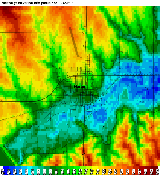
Below is the Elevation map of Norton, which displays elevation range with different colors. Scale of the first map is from 678 to 745 m (2224 to 2444 ft) with average elevation of 709 meters (=2326 ft) [note 1]
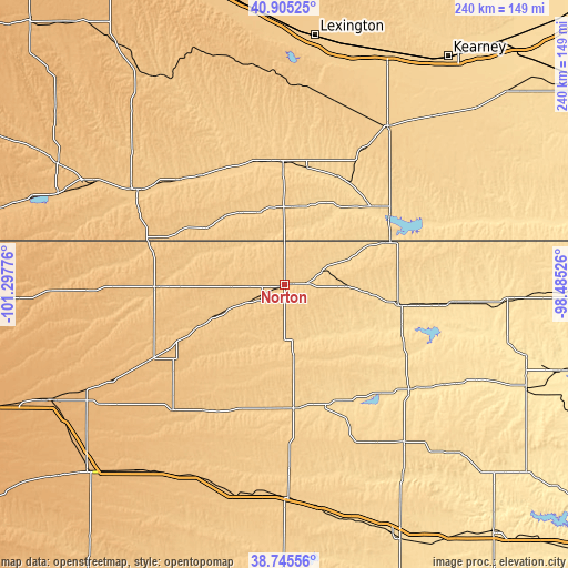
These maps also provides idea of topography and contour of this city, they are displayed at different zoom levels. More info about maps, scale and edge coordinates you can find below images.
| \ | Map #1 | Topo.Map |
| Scale [m] | 678..745 m | × |
| Scale [ft] | 2224..2444 ft | × |
| Average | 709 m = 2326 ft | × |
| Width | 7.5 km = 4.7 mi | 240.1 km = 149.2 mi |
| Height | 7.5 km = 4.7 mi | 240.1 km = 149.2 mi |
| ↑Max Latitude | 39.867628° | 40.90525° |
| Latitude at center | 39.83389° | 39.83389° |
| ↓Min Latitude | 39.800136° | 38.74556° |
| ← Min Longitude | -99.935455° | -101.29776° |
| Longitude center | -99.89151° | -99.89151° |
| →Max Longitude | -99.847565° | -98.48526° |
Nearby cities:
Cities around Norton sort by population:
• McCook elevation 791 m
74.7 km,  303°
303°
• Holdrege 716 m
80.7 km,  33°
33°
• Phillipsburg 599 m
49.2 km,  100°
100°
• Plainville 659 m
83.8 km,  142°
142°
• Oberlin 783 m
54.4 km,  268°
268°
• Hill City 673 m
52.3 km,  175°
175°
• Stockton 556 m
69.4 km,  129°
129°
• Hoxie 832 m
70.9 km,  221°
221°
• Alma 608 m
53.8 km,  56°
56°
• Cambridge 695 m
55 km,  334°
334°
• Arapahoe 668 m
52.3 km,  359°
359°
• Beaver City 669 m
34.2 km,  8°
8°
Multilingual:
 En español:
Norton elevación 713 m.
 En France:
Norton élévation 713 m.


Sources and notes:
- [note 1] Map square and city borders are not equal. Map elevation data is calculated only from area inside that square.
- [src 1] Elevation data from geonames database provided with same terms of usage.
- [src 2] The elevation map of Norton is generated using elevation data from NASA's 3 arcsec (90m) resolution SRTM data.
- [src 3] Base (background) map © OpenStreetMap contributors tiles are generated by Geofabrik and OpenTopoMap.
Copyright & License:
This Norton Elevation Map is licensed under CC BY-SA. You may reuse any part from this page, if you give a proper credit by linking to this URL:
 More info on terms of use page.