McCook elevation
McCook (Nebraska, Red Willow County), United States elevation is 791 meters and McCook elevation in feet is 2595 ft above sea level [src 1]. McCook is a seat of a second-order administrative division (feature code) with elevation that is 512 meters (1680 ft) bigger than average city elevation in United States.
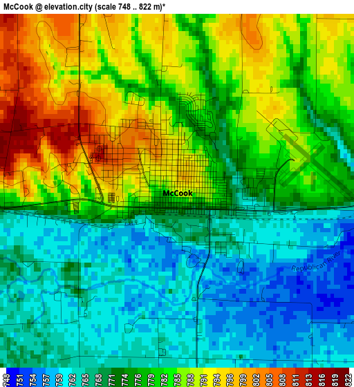
Below is the Elevation map of McCook, which displays elevation range with different colors. Scale of the first map is from 748 to 822 m (2454 to 2697 ft) with average elevation of 776.9 meters (=2549 ft) [note 1]
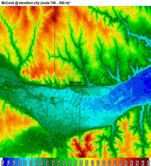
These maps also provides idea of topography and contour of this city, they are displayed at different zoom levels. More info about maps, scale and edge coordinates you can find below images.
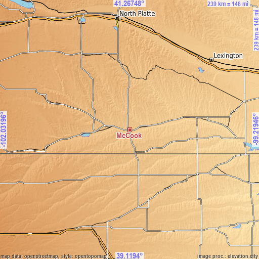
| \ | Map #1 | Map #2 | Topo.Map |
| Scale [m] | 748..822 m | 740..840 m | × |
| Scale [ft] | 2454..2697 ft | 2428..2756 ft | × |
| Average | 776.9 m = 2549 ft | 784.5 m = 2574 ft | × |
| Width | 7.46 km = 4.6 mi | 14.93 km = 9.3 mi | 238.8 km = 148.4 mi |
| Height | 7.46 km = 4.6 mi | 14.93 km = 9.3 mi | 238.8 km = 148.4 mi |
| ↑Max Latitude | 40.235506° | 40.269045° | 41.26748° |
| Latitude at center | 40.20195° | 40.20195° | 40.20195° |
| ↓Min Latitude | 40.168377° | 40.134788° | 39.1194° |
| ← Min Longitude | -100.669655° | -100.713601° | -102.03196° |
| Longitude center | -100.62571° | -100.62571° | -100.62571° |
| →Max Longitude | -100.581765° | -100.537819° | -99.21946° |
Nearby cities:
Cities around McCook sort by population:
• Gothenburg elevation 786 m
89.9 km,  25°
25°
• Norton 713 m
74.7 km,  123°
123°
• Oberlin 783 m
43.5 km,  168°
168°
• Atwood 874 m
56.5 km,  218°
218°
• Cambridge 695 m
40 km,  77°
77°
• Arapahoe 668 m
62.6 km, 79°
• Benkelman 913 m
79 km,  257°
257°
• Elwood 817 m
77.8 km,  56°
56°
• Beaver City 669 m
68 km,  96°
96°
• Trenton 818 m
33 km, 264°
• Hayes Center 936 m
47.9 km,  315°
315°
• Stockville 762 m
42.1 km, 29°
Multilingual:
 En español:
McCook elevación 791 m.
 En France:
McCook élévation 791 m.


Sources and notes:
- [note 1] Map square and city borders are not equal. Map elevation data is calculated only from area inside that square.
- [src 1] Elevation data from geonames database provided with same terms of usage.
- [src 2] The elevation map of McCook is generated using elevation data from NASA's 3 arcsec (90m) resolution SRTM data.
- [src 3] Base (background) map © OpenStreetMap contributors tiles are generated by Geofabrik and OpenTopoMap.
Copyright & License:
This McCook Elevation Map is licensed under CC BY-SA. You may reuse any part from this page, if you give a proper credit by linking to this URL:
 More info on terms of use page.