Phillipsburg elevation
Phillipsburg (Kansas, Phillips County), United States elevation is 599 meters and Phillipsburg elevation in feet is 1965 ft above sea level [src 1]. Phillipsburg is a seat of a second-order administrative division (feature code) with elevation that is 320 meters (1050 ft) bigger than average city elevation in United States.
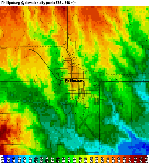
Below is the Elevation map of Phillipsburg, which displays elevation range with different colors. Scale of the first map is from 555 to 618 m (1821 to 2028 ft) with average elevation of 586.6 meters (=1925 ft) [note 1]
These maps also provides idea of topography and contour of this city, they are displayed at different zoom levels. More info about maps, scale and edge coordinates you can find below images.
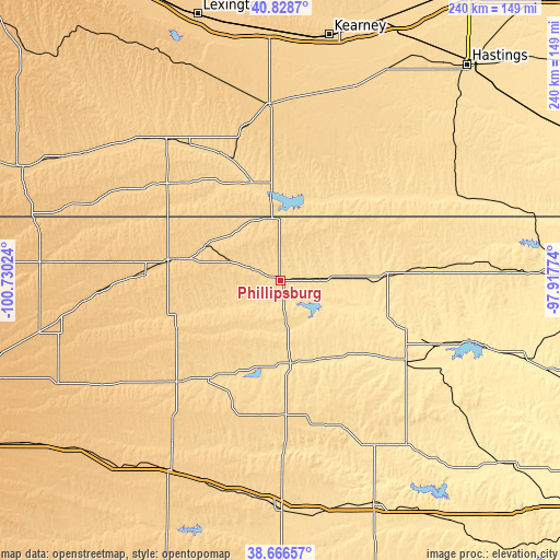
| \ | Map #1 | Topo.Map |
| Scale [m] | 555..618 m | × |
| Scale [ft] | 1821..2028 ft | × |
| Average | 586.6 m = 1925 ft | × |
| Width | 7.51 km = 4.7 mi | 240.4 km = 149.4 mi |
| Height | 7.51 km = 4.7 mi | 240.4 km = 149.4 mi |
| ↑Max Latitude | 39.789896° | 40.8287° |
| Latitude at center | 39.75612° | 39.75612° |
| ↓Min Latitude | 39.722328° | 38.66657° |
| ← Min Longitude | -99.367935° | -100.73024° |
| Longitude center | -99.32399° | -99.32399° |
| →Max Longitude | -99.280045° | -97.91774° |
Nearby cities:
Cities around Phillipsburg sort by population:
• Holdrege elevation 716 m
76.2 km,  357°
357°
• Norton 713 m
49.2 km,  280°
280°
• Plainville 659 m
58 km,  177°
177°
• Smith Center 549 m
46.1 km,  86°
86°
• Hill City 673 m
62.2 km,  225°
225°
• Osborne 478 m
64.3 km,  123°
123°
• Stockton 556 m
35.7 km,  171°
171°
• Alma 608 m
38.1 km, 355°
• Arapahoe 668 m
78.2 km,  321°
321°
• Red Cloud 527 m
77.9 km,  61°
61°
• Franklin 571 m
49.3 km,  39°
39°
• Beaver City 669 m
60.5 km,  314°
314°
Multilingual:
 En español:
Phillipsburg elevación 599 m.
 En France:
Phillipsburg élévation 599 m.
 Auf Deutsch:
Phillipsburg höhe über dem Meeresspiegel ist 599 m.

Sources and notes:
- [note 1] Map square and city borders are not equal. Map elevation data is calculated only from area inside that square.
- [src 1] Elevation data from geonames database provided with same terms of usage.
- [src 2] The elevation map of Phillipsburg is generated using elevation data from NASA's 3 arcsec (90m) resolution SRTM data.
- [src 3] Base (background) map © OpenStreetMap contributors tiles are generated by Geofabrik and OpenTopoMap.
Copyright & License:
This Phillipsburg Elevation Map is licensed under CC BY-SA. You may reuse any part from this page, if you give a proper credit by linking to this URL:
 More info on terms of use page.