Red Cloud elevation
Red Cloud (Nebraska, Webster County), United States elevation is 527 meters and Red Cloud elevation in feet is 1729 ft above sea level [src 1]. Red Cloud is a seat of a second-order administrative division (feature code) with elevation that is 248 meters (814 ft) bigger than average city elevation in United States.
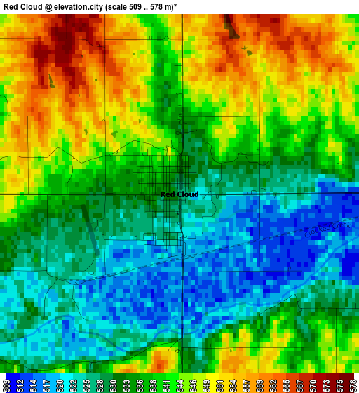
Below is the Elevation map of Red Cloud, which displays elevation range with different colors. Scale of the first map is from 509 to 578 m (1670 to 1896 ft) with average elevation of 536.9 meters (=1761 ft) [note 1]
These maps also provides idea of topography and contour of this city, they are displayed at different zoom levels. More info about maps, scale and edge coordinates you can find below images.
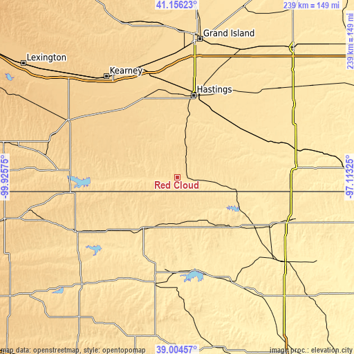
| \ | Map #1 | Topo.Map |
| Scale [m] | 509..578 m | × |
| Scale [ft] | 1670..1896 ft | × |
| Average | 536.9 m = 1761 ft | × |
| Width | 7.48 km = 4.6 mi | 239.2 km = 148.6 mi |
| Height | 7.48 km = 4.6 mi | 239.2 km = 148.6 mi |
| ↑Max Latitude | 40.122512° | 41.15623° |
| Latitude at center | 40.0889° | 40.0889° |
| ↓Min Latitude | 40.055272° | 39.00457° |
| ← Min Longitude | -98.563445° | -99.92575° |
| Longitude center | -98.5195° | -98.5195° |
| →Max Longitude | -98.475555° | -97.11325° |
Nearby cities:
Cities around Red Cloud sort by population:
• Hastings elevation 590 m
56.4 km,  11°
11°
• Minden 667 m
58.3 km,  321°
321°
• Phillipsburg 599 m
77.9 km,  241°
241°
• Superior 490 m
39 km,  101°
101°
• Gibbon 631 m
78.3 km,  339°
339°
• Smith Center 549 m
41.2 km,  213°
213°
• Osborne 478 m
73.8 km,  191°
191°
• Alma 608 m
71.7 km,  270°
270°
• Franklin 571 m
36.8 km, 271°
• Mankato 546 m
42.7 km,  141°
141°
• Clay Center 549 m
62.2 km,  39°
39°
• Nelson 520 m
40.4 km,  71°
71°
Multilingual:
 En español:
Red Cloud elevación 527 m.
 En France:
Red Cloud élévation 527 m.
 Auf Deutsch:
Red Cloud höhe über dem Meeresspiegel ist 527 m.

Sources and notes:
- [note 1] Map square and city borders are not equal. Map elevation data is calculated only from area inside that square.
- [src 1] Elevation data from geonames database provided with same terms of usage.
- [src 2] The elevation map of Red Cloud is generated using elevation data from NASA's 3 arcsec (90m) resolution SRTM data.
- [src 3] Base (background) map © OpenStreetMap contributors tiles are generated by Geofabrik and OpenTopoMap.
Copyright & License:
This Red Cloud Elevation Map is licensed under CC BY-SA. You may reuse any part from this page, if you give a proper credit by linking to this URL:
 More info on terms of use page.