Independence elevation
Independence (Kansas, Montgomery County), United States elevation is 247 meters and Independence elevation in feet is 810 ft above sea level [src 1]. Independence is a seat of a second-order administrative division (feature code) with elevation that is 32 meters (105 ft) smaller than average city elevation in United States.
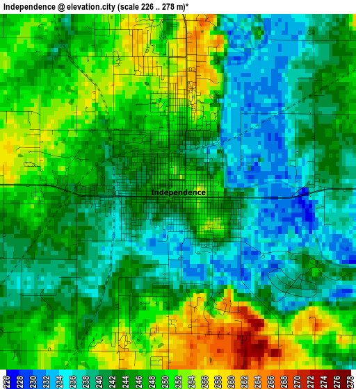
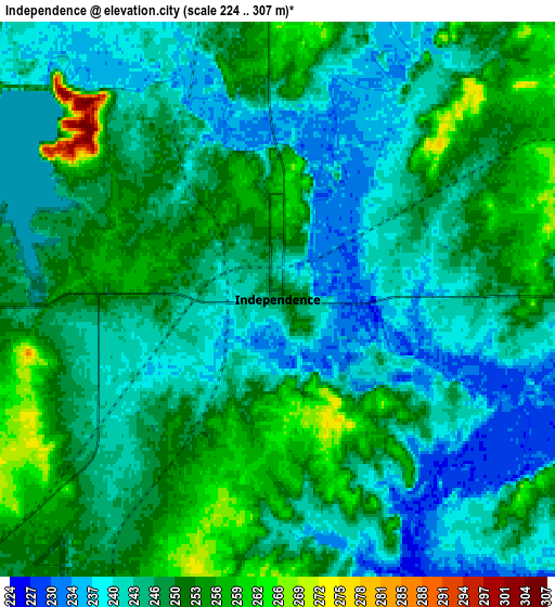
Below is the Elevation map of Independence, which displays elevation range with different colors. Scale of the first map is from 226 to 278 m (741 to 912 ft) with average elevation of 244.7 meters (=803 ft) [note 1]
These maps also provides idea of topography and contour of this city, they are displayed at different zoom levels. More info about maps, scale and edge coordinates you can find below images.
| \ | Map #1 | Map #2 | Topo.Map |
| Scale [m] | 226..278 m | 224..307 m | × |
| Scale [ft] | 741..912 ft | 735..1007 ft | × |
| Average | 244.7 m = 803 ft | 246.6 m = 809 ft | × |
| Width | 7.78 km = 4.8 mi | 15.56 km = 9.7 mi | 249 km = 154.7 mi |
| Height | 7.78 km = 4.8 mi | 15.56 km = 9.7 mi | 249 km = 154.7 mi |
| ↑Max Latitude | 37.259224° | 37.294193° | 38.33566° |
| Latitude at center | 37.22424° | 37.22424° | 37.22424° |
| ↓Min Latitude | 37.189239° | 37.154223° | 36.0962° |
| ← Min Longitude | -95.752255° | -95.796201° | -97.11456° |
| Longitude center | -95.70831° | -95.70831° | -95.70831° |
| →Max Longitude | -95.664365° | -95.620419° | -94.30206° |
Nearby cities:
Cities around Independence sort by population:
• Parsons elevation 281 m
41.6 km,  71°
71°
• Coffeyville 227 m
22.3 km,  158°
158°
• Chanute 297 m
55.2 km,  23°
23°
• Dewey 217 m
51.7 km,  202°
202°
• Neodesha 251 m
21.7 km,  6°
6°
• Fredonia 278 m
36 km,  343°
343°
• Cherryvale 258 m
14.7 km, 69°
• Caney 239 m
31.1 km,  220°
220°
• Oswego 282 m
53.4 km,  96°
96°
• Erie 277 m
56.1 km,  47°
47°
• Altamont 279 m
36.6 km, 95°
• Sedan 265 m
43.8 km,  255°
255°
Multilingual:
 En español:
Independence elevación 247 m.
 En France:
Independence élévation 247 m.
 Auf Deutsch:
Independence höhe über dem Meeresspiegel ist 247 m.

Sources and notes:
- [note 1] Map square and city borders are not equal. Map elevation data is calculated only from area inside that square.
- [src 1] Elevation data from geonames database provided with same terms of usage.
- [src 2] The elevation map of Independence is generated using elevation data from NASA's 3 arcsec (90m) resolution SRTM data.
- [src 3] Base (background) map © OpenStreetMap contributors tiles are generated by Geofabrik and OpenTopoMap.
Copyright & License:
This Independence Elevation Map is licensed under CC BY-SA. You may reuse any part from this page, if you give a proper credit by linking to this URL:
 More info on terms of use page.