Oswego elevation
Oswego (Kansas, Labette County), United States elevation is 282 meters and Oswego elevation in feet is 925 ft above sea level [src 1]. Oswego is a seat of a second-order administrative division (feature code) with elevation that is 3 meters (10 ft) bigger than average city elevation in United States.
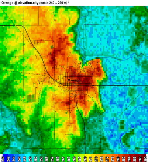
Below is the Elevation map of Oswego, which displays elevation range with different colors. Scale of the first map is from 240 to 290 m (787 to 951 ft) with average elevation of 260.7 meters (=855 ft) [note 1]
These maps also provides idea of topography and contour of this city, they are displayed at different zoom levels. More info about maps, scale and edge coordinates you can find below images.
| \ | Map #1 | Topo.Map |
| Scale [m] | 240..290 m | × |
| Scale [ft] | 787..951 ft | × |
| Average | 260.7 m = 855 ft | × |
| Width | 7.79 km = 4.8 mi | 249.2 km = 154.8 mi |
| Height | 7.79 km = 4.8 mi | 249.2 km = 154.8 mi |
| ↑Max Latitude | 37.202581° | 38.27983° |
| Latitude at center | 37.16757° | 37.16757° |
| ↓Min Latitude | 37.132543° | 36.03869° |
| ← Min Longitude | -95.153905° | -96.51621° |
| Longitude center | -95.10996° | -95.10996° |
| →Max Longitude | -95.066015° | -93.70371° |
Nearby cities:
Cities around Oswego sort by population:
• Pittsburg elevation 288 m
44.9 km,  52°
52°
• Miami 247 m
38.6 km,  147°
147°
• Parsons 281 m
23.4 km,  325°
325°
• Baxter Springs 259 m
36.9 km,  115°
115°
• Columbus 279 m
23.6 km,  89°
89°
• Galena 274 m
42.9 km,  103°
103°
• Girard 303 m
45.1 km,  32°
32°
• Commerce 249 m
33.5 km,  141°
141°
• Cherryvale 258 m
40.8 km,  286°
286°
• Erie 277 m
46.1 km,  345°
345°
• Chetopa 254 m
14.6 km,  173°
173°
• Altamont 279 m
16.8 km,  278°
278°
Multilingual:
 En español:
Oswego elevación 282 m.
 En France:
Oswego élévation 282 m.


Sources and notes:
- [note 1] Map square and city borders are not equal. Map elevation data is calculated only from area inside that square.
- [src 1] Elevation data from geonames database provided with same terms of usage.
- [src 2] The elevation map of Oswego is generated using elevation data from NASA's 3 arcsec (90m) resolution SRTM data.
- [src 3] Base (background) map © OpenStreetMap contributors tiles are generated by Geofabrik and OpenTopoMap.
Copyright & License:
This Oswego Elevation Map is licensed under CC BY-SA. You may reuse any part from this page, if you give a proper credit by linking to this URL:
 More info on terms of use page.