Caney elevation
Caney (Kansas, Montgomery County), United States elevation is 239 meters and Caney elevation in feet is 784 ft above sea level [src 1]. Caney is a populated place (feature code) with elevation that is 40 meters (131 ft) smaller than average city elevation in United States.
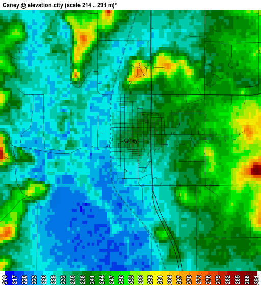
Below is the Elevation map of Caney, which displays elevation range with different colors. Scale of the first map is from 214 to 291 m (702 to 955 ft) with average elevation of 235.6 meters (=773 ft) [note 1]
These maps also provides idea of topography and contour of this city, they are displayed at different zoom levels. More info about maps, scale and edge coordinates you can find below images.
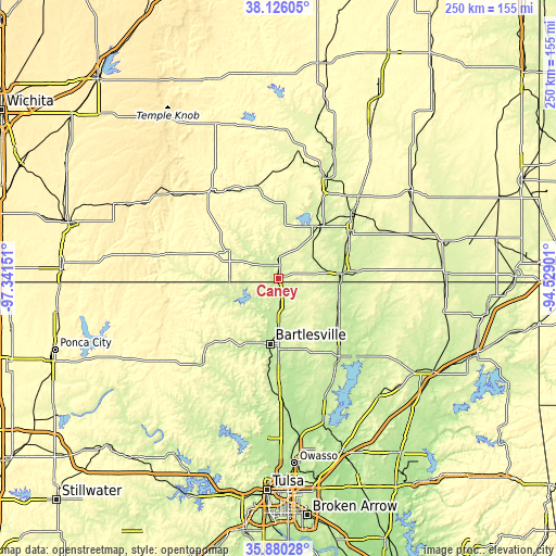
| \ | Map #1 | Topo.Map |
| Scale [m] | 214..291 m | × |
| Scale [ft] | 702..955 ft | × |
| Average | 235.6 m = 773 ft | × |
| Width | 7.8 km = 4.8 mi | 249.7 km = 155.2 mi |
| Height | 7.8 km = 4.8 mi | 249.7 km = 155.2 mi |
| ↑Max Latitude | 37.046543° | 38.12605° |
| Latitude at center | 37.01146° | 37.01146° |
| ↓Min Latitude | 36.976361° | 35.88028° |
| ← Min Longitude | -95.979205° | -97.34151° |
| Longitude center | -95.93526° | -95.93526° |
| →Max Longitude | -95.891315° | -94.52901° |
Nearby cities:
Cities around Caney sort by population:
• Bartlesville elevation 217 m
29.6 km,  187°
187°
• Coffeyville 227 m
28.5 km,  84°
84°
• Independence 247 m
31.1 km,  40°
40°
• Nowata 218 m
43.5 km,  142°
142°
• Pawhuska 255 m
52.3 km,  223°
223°
• Dewey 217 m
24 km,  180°
180°
• Neodesha 251 m
50.6 km,  26°
26°
• Fredonia 278 m
58.9 km,  9°
9°
• Cherryvale 258 m
44.5 km,  49°
49°
• Barnsdall 230 m
53.9 km,  201°
201°
• Sedan 265 m
25.7 km,  299°
299°
• Howard 320 m
58.7 km,  330°
330°
Multilingual:
 En español:
Caney elevación 239 m.
 En France:
Caney élévation 239 m.


Sources and notes:
- [note 1] Map square and city borders are not equal. Map elevation data is calculated only from area inside that square.
- [src 1] Elevation data from geonames database provided with same terms of usage.
- [src 2] The elevation map of Caney is generated using elevation data from NASA's 3 arcsec (90m) resolution SRTM data.
- [src 3] Base (background) map © OpenStreetMap contributors tiles are generated by Geofabrik and OpenTopoMap.
Copyright & License:
This Caney Elevation Map is licensed under CC BY-SA. You may reuse any part from this page, if you give a proper credit by linking to this URL:
 More info on terms of use page.