Temple elevation
Temple (Georgia, Carroll County), United States elevation is 355 meters and Temple elevation in feet is 1165 ft above sea level [src 1]. Temple is a populated place (feature code) with elevation that is 76 meters (249 ft) bigger than average city elevation in United States.
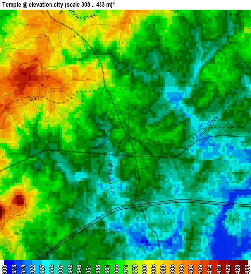
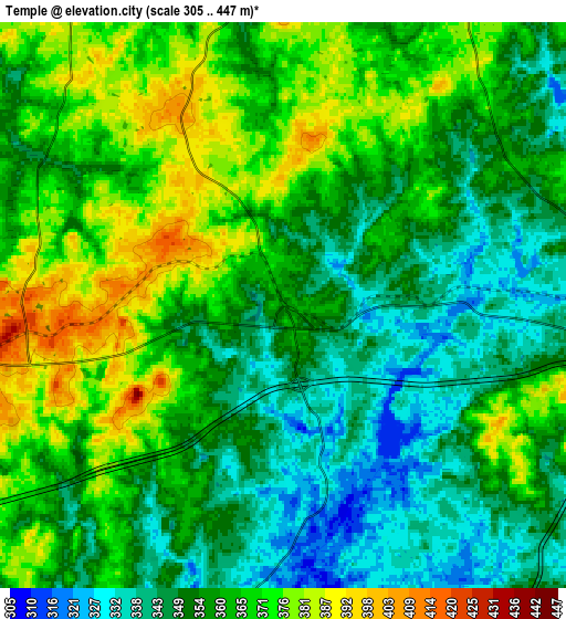
Below is the Elevation map of Temple, which displays elevation range with different colors. Scale of the first map is from 308 to 433 m (1010 to 1421 ft) with average elevation of 356 meters (=1168 ft) [note 1]
These maps also provides idea of topography and contour of this city, they are displayed at different zoom levels. More info about maps, scale and edge coordinates you can find below images.
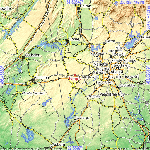
| \ | Map #1 | Map #2 | Topo.Map |
| Scale [m] | 308..433 m | 305..447 m | × |
| Scale [ft] | 1010..1421 ft | 1001..1467 ft | × |
| Average | 356 m = 1168 ft | 358.9 m = 1177 ft | × |
| Width | 8.13 km = 5.1 mi | 16.25 km = 10.1 mi | 260 km = 161.6 mi |
| Height | 8.13 km = 5.1 mi | 16.25 km = 10.1 mi | 260 km = 161.6 mi |
| ↑Max Latitude | 33.773587° | 33.810108° | 34.89847° |
| Latitude at center | 33.73705° | 33.73705° | 33.73705° |
| ↓Min Latitude | 33.700498° | 33.663929° | 32.5597° |
| ← Min Longitude | -85.076385° | -85.120331° | -86.43869° |
| Longitude center | -85.03244° | -85.03244° | -85.03244° |
| →Max Longitude | -84.988495° | -84.944549° | -83.62619° |
Nearby cities:
Cities around Temple sort by population:
• Douglasville elevation 370 m
26.4 km,  86°
86°
• Carrollton 335 m
17.9 km,  193°
193°
• Villa Rica 349 m
10.5 km, 93°
• Dallas 316 m
27.3 km,  40°
40°
• Bremen 428 m
10.6 km,  260°
260°
• Rockmart 239 m
29.5 km,  358°
358°
• Hiram 296 m
29.3 km,  58°
58°
• Tallapoosa 350 m
23.6 km,  272°
272°
• Chattahoochee Hills 248 m
32.6 km,  129°
129°
• Bowdon 333 m
30.1 km,  222°
222°
• Mount Zion 366 m
18.3 km,  231°
231°
• Buchanan 378 m
16.2 km,  296°
296°
Multilingual:
 En español:
Temple elevación 355 m.
 En France:
Temple élévation 355 m.


Sources and notes:
- [note 1] Map square and city borders are not equal. Map elevation data is calculated only from area inside that square.
- [src 1] Elevation data from geonames database provided with same terms of usage.
- [src 2] The elevation map of Temple is generated using elevation data from NASA's 3 arcsec (90m) resolution SRTM data.
- [src 3] Base (background) map © OpenStreetMap contributors tiles are generated by Geofabrik and OpenTopoMap.
Copyright & License:
This Temple Elevation Map is licensed under CC BY-SA. You may reuse any part from this page, if you give a proper credit by linking to this URL:
 More info on terms of use page.