Carrollton elevation
Carrollton (Georgia, Carroll County), United States elevation is 335 meters and Carrollton elevation in feet is 1099 ft above sea level [src 1]. Carrollton is a seat of a second-order administrative division (feature code) with elevation that is 56 meters (184 ft) bigger than average city elevation in United States.
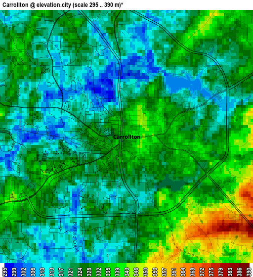
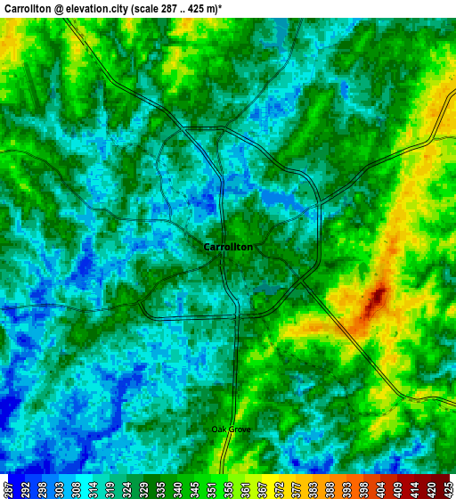
Below is the Elevation map of Carrollton, which displays elevation range with different colors. Scale of the first map is from 295 to 390 m (968 to 1280 ft) with average elevation of 325.1 meters (=1067 ft) [note 1]
These maps also provides idea of topography and contour of this city, they are displayed at different zoom levels. More info about maps, scale and edge coordinates you can find below images.
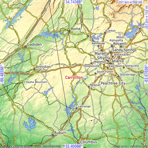
| \ | Map #1 | Map #2 | Topo.Map |
| Scale [m] | 295..390 m | 287..425 m | × |
| Scale [ft] | 968..1280 ft | 942..1394 ft | × |
| Average | 325.1 m = 1067 ft | 331.1 m = 1086 ft | × |
| Width | 8.14 km = 5.1 mi | 16.28 km = 10.1 mi | 260.5 km = 161.9 mi |
| Height | 8.14 km = 5.1 mi | 16.28 km = 10.1 mi | 260.5 km = 161.9 mi |
| ↑Max Latitude | 33.616714° | 33.653302° | 34.74368° |
| Latitude at center | 33.58011° | 33.58011° | 33.58011° |
| ↓Min Latitude | 33.543491° | 33.506856° | 32.40064° |
| ← Min Longitude | -85.120555° | -85.164501° | -86.48286° |
| Longitude center | -85.07661° | -85.07661° | -85.07661° |
| →Max Longitude | -85.032665° | -84.988719° | -83.67036° |
Nearby cities:
Cities around Carrollton sort by population:
• Newnan elevation 309 m
33.9 km,  130°
130°
• Douglasville 370 m
35.9 km,  57°
57°
• Villa Rica 349 m
22.3 km,  40°
40°
• Bremen 428 m
16.9 km,  337°
337°
• Temple 355 m
17.9 km,  13°
13°
• Tallapoosa 350 m
26.8 km,  313°
313°
• Chattahoochee Hills 248 m
29.5 km,  96°
96°
• Bowdon 333 m
17 km,  253°
253°
• Mount Zion 366 m
11.9 km,  300°
300°
• East Newnan 287 m
37.8 km, 132°
• Buchanan 378 m
26.8 km, 337°
• Franklin 204 m
33.7 km,  183°
183°
Multilingual:
 En español:
Carrollton elevación 335 m.
 En France:
Carrollton élévation 335 m.
 Auf Deutsch:
Carrollton höhe über dem Meeresspiegel ist 335 m.

Sources and notes:
- [note 1] Map square and city borders are not equal. Map elevation data is calculated only from area inside that square.
- [src 1] Elevation data from geonames database provided with same terms of usage.
- [src 2] The elevation map of Carrollton is generated using elevation data from NASA's 3 arcsec (90m) resolution SRTM data.
- [src 3] Base (background) map © OpenStreetMap contributors tiles are generated by Geofabrik and OpenTopoMap.
Copyright & License:
This Carrollton Elevation Map is licensed under CC BY-SA. You may reuse any part from this page, if you give a proper credit by linking to this URL:
 More info on terms of use page.