Monroeville elevation
Monroeville (Alabama, Monroe County), United States elevation is 131 meters and Monroeville elevation in feet is 430 ft above sea level [src 1]. Monroeville is a seat of a second-order administrative division (feature code) with elevation that is 148 meters (486 ft) smaller than average city elevation in United States.
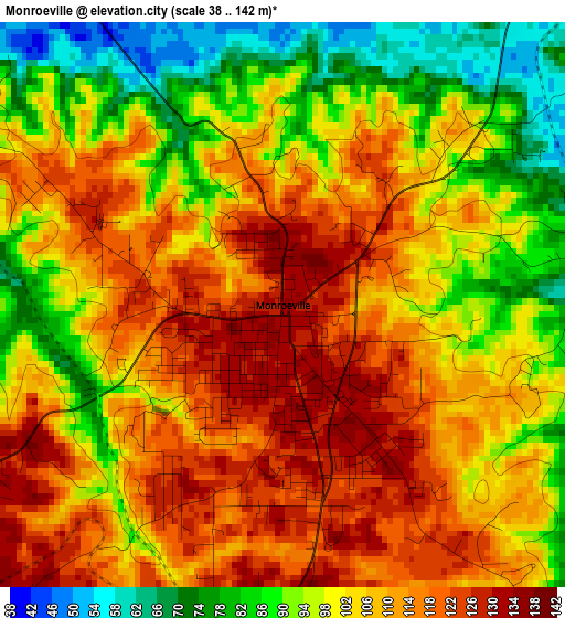
Below is the Elevation map of Monroeville, which displays elevation range with different colors. Scale of the first map is from 38 to 142 m (125 to 466 ft) with average elevation of 103.9 meters (=341 ft) [note 1]
These maps also provides idea of topography and contour of this city, they are displayed at different zoom levels. More info about maps, scale and edge coordinates you can find below images.
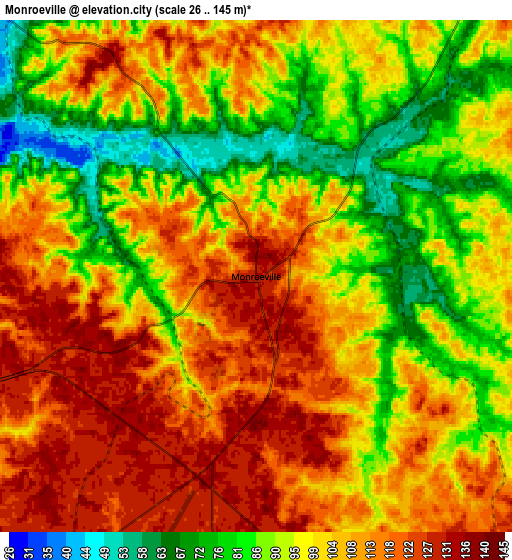
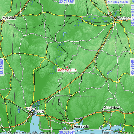
| \ | Map #1 | Map #2 | Topo.Map |
| Scale [m] | 38..142 m | 26..145 m | × |
| Scale [ft] | 125..466 ft | 85..476 ft | × |
| Average | 103.9 m = 341 ft | 101.5 m = 333 ft | × |
| Width | 8.33 km = 5.2 mi | 16.66 km = 10.4 mi | 266.5 km = 165.6 mi |
| Height | 8.33 km = 5.2 mi | 16.66 km = 10.4 mi | 266.6 km = 165.7 mi |
| ↑Max Latitude | 31.565391° | 31.602827° | 32.71886° |
| Latitude at center | 31.52794° | 31.52794° | 31.52794° |
| ↓Min Latitude | 31.490474° | 31.452993° | 30.32164° |
| ← Min Longitude | -87.368655° | -87.412601° | -88.73096° |
| Longitude center | -87.32471° | -87.32471° | -87.32471° |
| →Max Longitude | -87.280765° | -87.236819° | -85.91846° |
Nearby cities:
Cities around Monroeville sort by population:
• Atmore elevation 89 m
58.3 km,  196°
196°
• Brewton 28 m
52.8 km,  152°
152°
• Jackson 69 m
54 km,  267°
267°
• Thomasville 121 m
57.9 km,  317°
317°
• Evergreen 90 m
36.4 km,  106°
106°
• East Brewton 34 m
54.4 km, 152°
• Camden 66 m
51.6 km,  3°
3°
• Century 35 m
61.9 km,  174°
174°
• Georgiana 92 m
56.5 km,  77°
77°
• Grove Hill 155 m
47.3 km,  295°
295°
• Flomaton 27 m
59 km, 174°
• Frisco City 127 m
12.8 km,  214°
214°
Multilingual:
 En español:
Monroeville elevación 131 m.
 En France:
Monroeville élévation 131 m.
 Auf Deutsch:
Monroeville höhe über dem Meeresspiegel ist 131 m.

Sources and notes:
- [note 1] Map square and city borders are not equal. Map elevation data is calculated only from area inside that square.
- [src 1] Elevation data from geonames database provided with same terms of usage.
- [src 2] The elevation map of Monroeville is generated using elevation data from NASA's 3 arcsec (90m) resolution SRTM data.
- [src 3] Base (background) map © OpenStreetMap contributors tiles are generated by Geofabrik and OpenTopoMap.
Copyright & License:
This Monroeville Elevation Map is licensed under CC BY-SA. You may reuse any part from this page, if you give a proper credit by linking to this URL:
 More info on terms of use page.