Myronivka elevation
Myronivka (Kyiv), Ukraine elevation is 122 meters and Myronivka elevation in feet is 400 ft above sea level [src 1]. Myronivka is a populated place (feature code) with elevation that is 35 meters (115 ft) smaller than average city elevation in Ukraine.
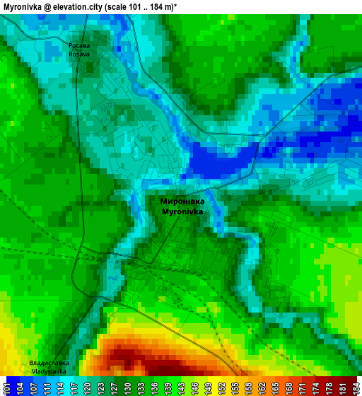
Below is the Elevation map of Myronivka, which displays elevation range with different colors. Scale of the first map is from 101 to 184 m (331 to 604 ft) with average elevation of 129.8 meters (=426 ft) [note 1]
These maps also provides idea of topography and contour of this city, they are displayed at different zoom levels. More info about maps, scale and edge coordinates you can find below images.
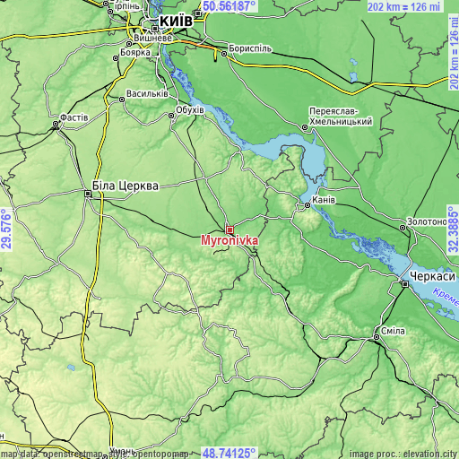
| \ | Map #1 | Map #2 | Topo.Map |
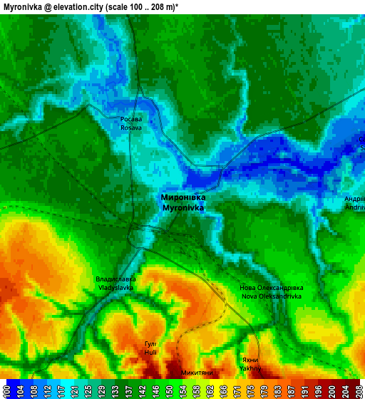
| Scale [m] | 101..184 m | 100..208 m | × |
| Scale [ft] | 331..604 ft | 328..682 ft | × |
| Average | 129.8 m = 426 ft | 140.5 m = 461 ft | × |
| Width | 6.33 km = 3.9 mi | 12.65 km = 7.9 mi | 202.4 km = 125.8 mi |
| Height | 6.33 km = 3.9 mi | 12.65 km = 7.9 mi | 202.4 km = 125.8 mi |
| ↑Max Latitude | 49.688508° | 49.71693° | 50.56187° |
| Latitude at center | 49.66007° | 49.66007° | 49.66007° |
| ↓Min Latitude | 49.631615° | 49.603143° | 48.74125° |
| ← Min Longitude | 30.938305° | 30.894359° | 29.576° |
| Longitude center | 30.98225° | 30.98225° | 30.98225° |
| →Max Longitude | 31.026195° | 31.070141° | 32.3885° |
Nearby cities:
Cities around Myronivka sort by population:
• Kaniv elevation 126 m
35.8 km,  73°
73°
• Korsun-Shevchenkivskyi 119 m
33.4 km,  143°
143°
• Bohuslav 164 m
14.6 km,  212°
212°
• Kaharlyk 159 m
25.1 km,  333°
333°
• Tarashcha 189 m
37 km,  252°
252°
• Uzyn 179 m
44.8 km,  294°
294°
• Rzhyshchiv 90 m
34.6 km,  7°
7°
• Lysianka 160 m
46.7 km,  193°
193°
• Stebliv 125 m
29.9 km,  163°
163°
• Karapyshi 146 m
14 km,  261°
261°
• Mirovka 168 m
39.7 km,  319°
319°
• Rokytne 155 m
36.7 km,  274°
274°
Multilingual:
 En español:
Myronivka elevación 122 m.
 En France:
Myronivka élévation 122 m.
 Auf Deutsch:
Myroniwka höhe über dem Meeresspiegel ist 122 m.

Sources and notes:
- [note 1] Map square and city borders are not equal. Map elevation data is calculated only from area inside that square.
- [src 1] Elevation data from geonames database provided with same terms of usage.
- [src 2] The elevation map of Myronivka is generated using elevation data from NASA's 3 arcsec (90m) resolution SRTM data.
- [src 3] Base (background) map © OpenStreetMap contributors tiles are generated by Geofabrik and OpenTopoMap.
Copyright & License:
This Myronivka Elevation Map is licensed under CC BY-SA. You may reuse any part from this page, if you give a proper credit by linking to this URL:
 More info on terms of use page.