Tarashcha elevation
Tarashcha (Kyiv), Ukraine elevation is 189 meters and Tarashcha elevation in feet is 620 ft above sea level [src 1]. Tarashcha is a seat of a second-order administrative division (feature code) with elevation that is 32 meters (105 ft) bigger than average city elevation in Ukraine.
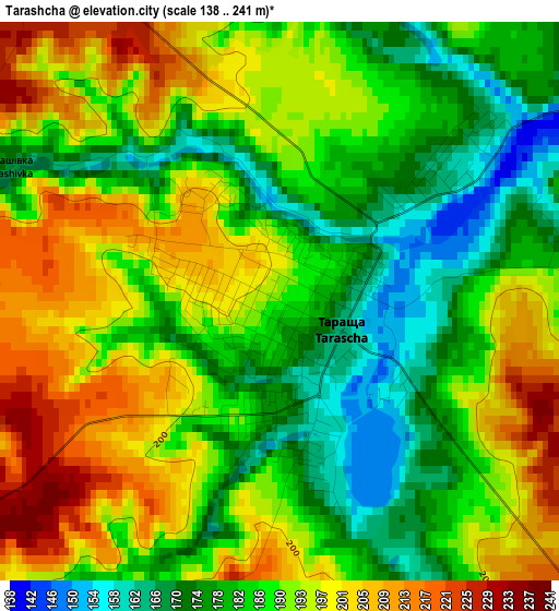
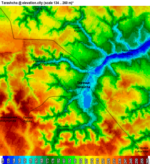
Below is the Elevation map of Tarashcha, which displays elevation range with different colors. Scale of the first map is from 138 to 241 m (453 to 791 ft) with average elevation of 188.7 meters (=619 ft) [note 1]
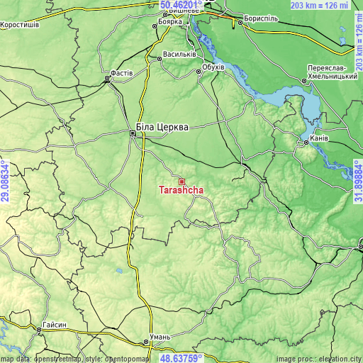
These maps also provides idea of topography and contour of this city, they are displayed at different zoom levels. More info about maps, scale and edge coordinates you can find below images.
| \ | Map #1 | Map #2 | Topo.Map |
| Scale [m] | 138..241 m | 134..260 m | × |
| Scale [ft] | 453..791 ft | 440..853 ft | × |
| Average | 188.7 m = 619 ft | 203.1 m = 666 ft | × |
| Width | 6.34 km = 3.9 mi | 12.68 km = 7.9 mi | 202.9 km = 126.1 mi |
| Height | 6.34 km = 3.9 mi | 12.68 km = 7.9 mi | 202.8 km = 126 mi |
| ↑Max Latitude | 49.586818° | 49.615299° | 50.46201° |
| Latitude at center | 49.55832° | 49.55832° | 49.55832° |
| ↓Min Latitude | 49.529806° | 49.501274° | 48.63759° |
| ← Min Longitude | 30.448645° | 30.404699° | 29.08634° |
| Longitude center | 30.49259° | 30.49259° | 30.49259° |
| →Max Longitude | 30.536535° | 30.580481° | 31.89884° |
Nearby cities:
Cities around Tarashcha sort by population:
• Bila Tserkva elevation 178 m
39.1 km,  315°
315°
• Bohuslav 164 m
27.6 km,  92°
92°
• Kaharlyk 159 m
41.5 km,  35°
35°
• Myronivka 122 m
37 km,  72°
72°
• Uzyn 179 m
30.3 km,  349°
349°
• Lysianka 160 m
41.9 km,  144°
144°
• Volodarka 172 m
42 km,  264°
264°
• Roskoshnyy 240 m
30.5 km,  226°
226°
• Kalynove 174 m
19.9 km,  188°
188°
• Karapyshi 146 m
23.4 km, 66°
• Stavyshche 210 m
28.7 km, 229°
• Rokytne 155 m
14.3 km, 354°
Multilingual:
 En español:
Tarashcha elevación 189 m.
 En France:
Tarashcha élévation 189 m.
 Auf Deutsch:
Tarashcha höhe über dem Meeresspiegel ist 189 m.

Sources and notes:
- [note 1] Map square and city borders are not equal. Map elevation data is calculated only from area inside that square.
- [src 1] Elevation data from geonames database provided with same terms of usage.
- [src 2] The elevation map of Tarashcha is generated using elevation data from NASA's 3 arcsec (90m) resolution SRTM data.
- [src 3] Base (background) map © OpenStreetMap contributors tiles are generated by Geofabrik and OpenTopoMap.
Copyright & License:
This Tarashcha Elevation Map is licensed under CC BY-SA. You may reuse any part from this page, if you give a proper credit by linking to this URL:
 More info on terms of use page.