Lysianka elevation
Lysianka (Cherkasy), Ukraine elevation is 160 meters and Lysianka elevation in feet is 525 ft above sea level [src 1]. Lysianka is a seat of a second-order administrative division (feature code) with elevation that is 3 meters (10 ft) bigger than average city elevation in Ukraine.
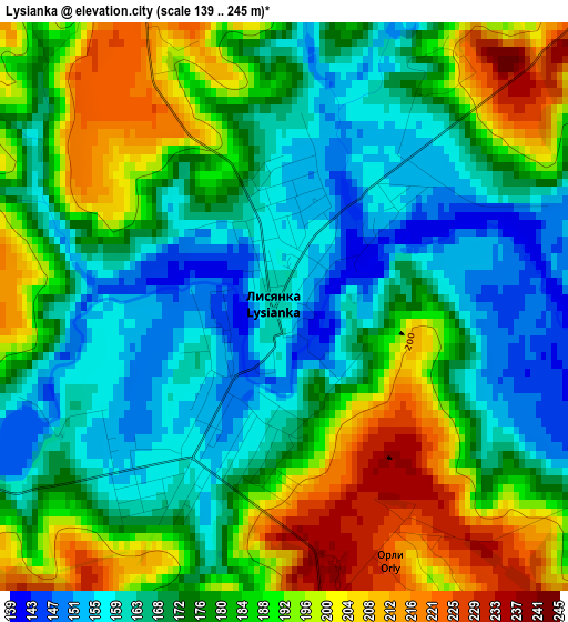
Below is the Elevation map of Lysianka, which displays elevation range with different colors. Scale of the first map is from 139 to 245 m (456 to 804 ft) with average elevation of 179 meters (=587 ft) [note 1]
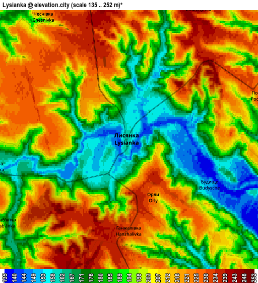
These maps also provides idea of topography and contour of this city, they are displayed at different zoom levels. More info about maps, scale and edge coordinates you can find below images.
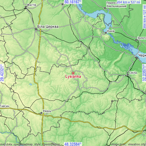
| \ | Map #1 | Map #2 | Topo.Map |
| Scale [m] | 139..245 m | 135..252 m | × |
| Scale [ft] | 456..804 ft | 443..827 ft | × |
| Average | 179 m = 587 ft | 198.4 m = 651 ft | × |
| Width | 6.38 km = 4 mi | 12.76 km = 7.9 mi | 204.1 km = 126.8 mi |
| Height | 6.38 km = 4 mi | 12.76 km = 7.9 mi | 204.1 km = 126.8 mi |
| ↑Max Latitude | 49.280966° | 49.309625° | 50.16167° |
| Latitude at center | 49.25229° | 49.25229° | 49.25229° |
| ↓Min Latitude | 49.223597° | 49.194888° | 48.32584° |
| ← Min Longitude | 30.785515° | 30.741569° | 29.42321° |
| Longitude center | 30.82946° | 30.82946° | 30.82946° |
| →Max Longitude | 30.873405° | 30.917351° | 32.23571° |
Nearby cities:
Cities around Lysianka sort by population:
• Vatutine elevation 141 m
31.3 km,  147°
147°
• Zvenihorodka 158 m
21.8 km, 152°
• Korsun-Shevchenkivskyi 119 m
36.2 km,  59°
59°
• Bohuslav 164 m
33.2 km,  5°
5°
• Talne 127 m
41.6 km,  193°
193°
• Tarashcha 189 m
41.9 km,  324°
324°
• Yerky 123 m
31.3 km,  158°
158°
• Stebliv 125 m
25.6 km,  49°
49°
• Kalynove 174 m
31 km,  297°
297°
• Yurkivka 128 m
32.8 km,  144°
144°
• Buky 225 m
35.7 km,  240°
240°
• Katerynopil 140 m
34.5 km, 162°
Multilingual:
 En español:
Lysianka elevación 160 m.
 En France:
Lysianka élévation 160 m.
 Auf Deutsch:
Lysianka höhe über dem Meeresspiegel ist 160 m.

Sources and notes:
- [note 1] Map square and city borders are not equal. Map elevation data is calculated only from area inside that square.
- [src 1] Elevation data from geonames database provided with same terms of usage.
- [src 2] The elevation map of Lysianka is generated using elevation data from NASA's 3 arcsec (90m) resolution SRTM data.
- [src 3] Base (background) map © OpenStreetMap contributors tiles are generated by Geofabrik and OpenTopoMap.
Copyright & License:
This Lysianka Elevation Map is licensed under CC BY-SA. You may reuse any part from this page, if you give a proper credit by linking to this URL:
 More info on terms of use page.