Stebliv elevation
Stebliv (Cherkasy), Ukraine elevation is 125 meters and Stebliv elevation in feet is 410 ft above sea level [src 1]. Stebliv is a populated place (feature code) with elevation that is 32 meters (105 ft) smaller than average city elevation in Ukraine.
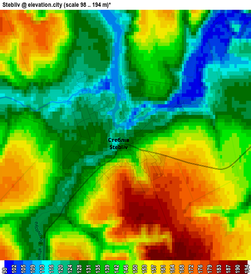
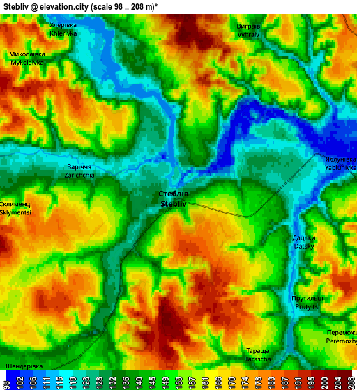
Below is the Elevation map of Stebliv, which displays elevation range with different colors. Scale of the first map is from 98 to 194 m (322 to 636 ft) with average elevation of 142.8 meters (=469 ft) [note 1]
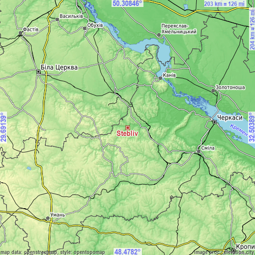
These maps also provides idea of topography and contour of this city, they are displayed at different zoom levels. More info about maps, scale and edge coordinates you can find below images.
| \ | Map #1 | Map #2 | Topo.Map |
| Scale [m] | 98..194 m | 98..208 m | × |
| Scale [ft] | 322..636 ft | 322..682 ft | × |
| Average | 142.8 m = 469 ft | 150.6 m = 494 ft | × |
| Width | 6.36 km = 4 mi | 12.72 km = 7.9 mi | 203.5 km = 126.4 mi |
| Height | 6.36 km = 4 mi | 12.72 km = 7.9 mi | 203.5 km = 126.4 mi |
| ↑Max Latitude | 49.430449° | 49.459021° | 50.30846° |
| Latitude at center | 49.40186° | 49.40186° | 49.40186° |
| ↓Min Latitude | 49.373254° | 49.344632° | 48.4782° |
| ← Min Longitude | 31.053695° | 31.009749° | 29.69139° |
| Longitude center | 31.09764° | 31.09764° | 31.09764° |
| →Max Longitude | 31.141585° | 31.185531° | 32.50389° |
Nearby cities:
Cities around Stebliv sort by population:
• Vatutine elevation 141 m
43.1 km,  183°
183°
• Zvenihorodka 158 m
37.2 km,  194°
194°
• Korsun-Shevchenkivskyi 119 m
11.8 km,  80°
80°
• Bohuslav 164 m
23 km,  315°
315°
• Horodyshche 114 m
28.3 km,  117°
117°
• Myronivka 122 m
29.9 km,  343°
343°
• Lysianka 160 m
25.6 km,  229°
229°
• Yerky 123 m
46.4 km, 189°
• Mliiv 90 m
31.2 km,  103°
103°
• Karapyshi 146 m
34.8 km, 320°
• Yurkivka 128 m
43.5 km, 180°
• Tsvitkove 175 m
42.3 km,  131°
131°
Multilingual:
 En español:
Stebliv elevación 125 m.
 En France:
Stebliv élévation 125 m.


Sources and notes:
- [note 1] Map square and city borders are not equal. Map elevation data is calculated only from area inside that square.
- [src 1] Elevation data from geonames database provided with same terms of usage.
- [src 2] The elevation map of Stebliv is generated using elevation data from NASA's 3 arcsec (90m) resolution SRTM data.
- [src 3] Base (background) map © OpenStreetMap contributors tiles are generated by Geofabrik and OpenTopoMap.
Copyright & License:
This Stebliv Elevation Map is licensed under CC BY-SA. You may reuse any part from this page, if you give a proper credit by linking to this URL:
 More info on terms of use page.