Tsvitkove elevation
Tsvitkove (Cherkasy), Ukraine elevation is 175 meters and Tsvitkove elevation in feet is 574 ft above sea level [src 1]. Tsvitkove is a populated place (feature code) with elevation that is 18 meters (59 ft) bigger than average city elevation in Ukraine.
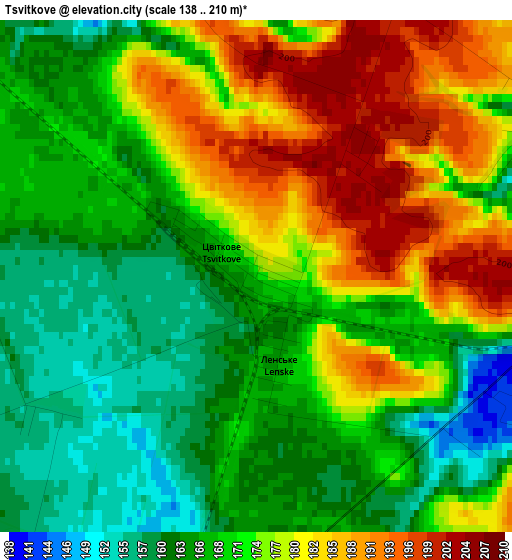
Below is the Elevation map of Tsvitkove, which displays elevation range with different colors. Scale of the first map is from 138 to 210 m (453 to 689 ft) with average elevation of 172.4 meters (=566 ft) [note 1]
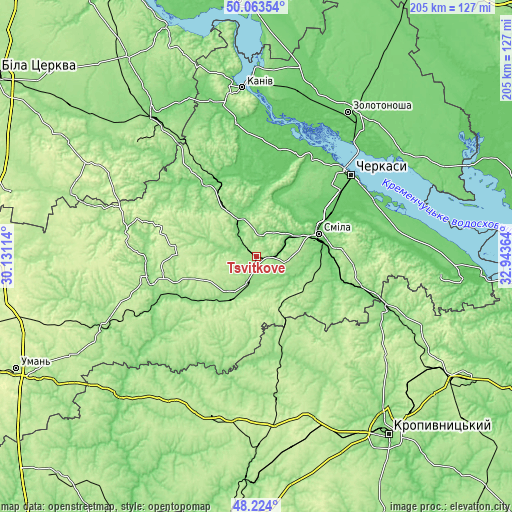
These maps also provides idea of topography and contour of this city, they are displayed at different zoom levels. More info about maps, scale and edge coordinates you can find below images.
| \ | Map #1 | Topo.Map |
| Scale [m] | 138..210 m | × |
| Scale [ft] | 453..689 ft | × |
| Average | 172.4 m = 566 ft | × |
| Width | 6.39 km = 4 mi | 204.5 km = 127.1 mi |
| Height | 6.39 km = 4 mi | 204.5 km = 127.1 mi |
| ↑Max Latitude | 49.181044° | 50.06354° |
| Latitude at center | 49.15231° | 49.15231° |
| ↓Min Latitude | 49.123559° | 48.224° |
| ← Min Longitude | 31.493445° | 30.13114° |
| Longitude center | 31.53739° | 31.53739° |
| →Max Longitude | 31.581335° | 32.94364° |
Nearby cities:
Cities around Tsvitkove sort by population:
• Smila elevation 101 m
26.6 km,  72°
72°
• Vatutine 141 m
37.8 km,  246°
246°
• Zvenihorodka 158 m
42.3 km,  258°
258°
• Korsun-Shevchenkivskyi 119 m
35.9 km,  325°
325°
• Shpola 150 m
19.2 km,  212°
212°
• Horodyshche 114 m
16.2 km,  335°
335°
• Novomyrhorod 140 m
42 km,  169°
169°
• Ruska Poliana 116 m
40.5 km,  43°
43°
• Lebedyn 197 m
21.1 km,  182°
182°
• Mliiv 90 m
20.6 km,  355°
355°
• Kapitanivka 193 m
29.2 km,  153°
153°
• Yurkivka 128 m
36.3 km,  244°
244°
Multilingual:
 En español:
Tsvitkove elevación 175 m.
 En France:
Tsvitkove élévation 175 m.
 Auf Deutsch:
Zwitkowe höhe über dem Meeresspiegel ist 175 m.

Sources and notes:
- [note 1] Map square and city borders are not equal. Map elevation data is calculated only from area inside that square.
- [src 1] Elevation data from geonames database provided with same terms of usage.
- [src 2] The elevation map of Tsvitkove is generated using elevation data from NASA's 3 arcsec (90m) resolution SRTM data.
- [src 3] Base (background) map © OpenStreetMap contributors tiles are generated by Geofabrik and OpenTopoMap.
Copyright & License:
This Tsvitkove Elevation Map is licensed under CC BY-SA. You may reuse any part from this page, if you give a proper credit by linking to this URL:
 More info on terms of use page.